IMAGES TAKEN NEAR TO
Balcombe Road, HORLEY, RH6 9BX
Introduction
This page details the photographs taken nearby to Balcombe Road, RH6 9BX by members of the Geograph project.
The Geograph project started in 2005 with the aim of publishing, organising and preserving representative images for every square kilometre of Great Britain, Ireland and the Isle of Man.

There are currently over 7.5m images from over14,400 individuals and you can help contribute to the project by visiting https://www.geograph.org.uk
Image Map
Images are licensed for reuse under creativecommons.org/licenses/by-sa/2.0
Notes
- Clicking on the map will re-center to the selected point.
- The higher the marker number, the further away the image location is from the centre of the postcode.
Image Listing (58 Images Found)
Images are licensed for reuse under creativecommons.org/licenses/by-sa/2.0
Image
Details
Distance
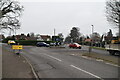
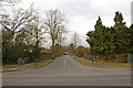
2
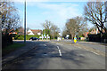
Roundabout, Balcombe Road and Victoria Road, Horley
Image: © Robin Webster
Taken: 7 Feb 2018
0.03 miles
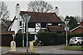
3
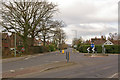
Balcombe Road Roundabout
Looking along Victoria Road with Waitrose in the distance (see Image).
Image: © Ian Capper
Taken: 9 Mar 2010
0.03 miles
4
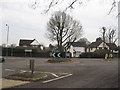
Roundabout on the Balcombe Road, Horley
Image: © Richard Rogerson
Taken: 24 Mar 2010
0.04 miles
6
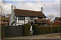
The Knapp
Despite appearing much older, this cottage in Balcombe Gardens was only built in 1924. Nevertheless, it is considered important enough architecturally to be locally listed. It was designed by local architect Blunden Shadbolt (see http://www.blundenshadbolt.co.uk/ ), an Arts and Crafts specialist who used recycled materials where possible, to give his buildings an appearance of age. It was originally lived in by Henry Harrison Stockdale Ross, a local solicitor, whose firm he founded is still practising (see http://www.rossandson.co.uk/ ).
Image: © Ian Capper
Taken: 9 Mar 2010
0.04 miles
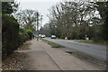
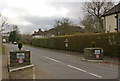
9
Limes Avenue
Originally laid out in 1936, with some of its original Lime trees still standing, but others having had to be replaced. Seen here from opposite its junction with Balcombe Road.
Image: © Ian Capper
Taken: 9 Mar 2010
0.05 miles
10
Castle Drive
A private road off Balcombe Road, largely developed in the 1930s. The name refers to Thunderfield Castle, which lies beyond the end of the road (see Image).
Image: © Ian Capper
Taken: 9 Mar 2010
0.06 miles