IMAGES TAKEN NEAR TO
Stonecourt Close, HORLEY, RH6 9AS
Introduction
This page details the photographs taken nearby to Stonecourt Close, RH6 9AS by members of the Geograph project.
The Geograph project started in 2005 with the aim of publishing, organising and preserving representative images for every square kilometre of Great Britain, Ireland and the Isle of Man.

There are currently over 7.5m images from over14,400 individuals and you can help contribute to the project by visiting https://www.geograph.org.uk
Image Map
Images are licensed for reuse under creativecommons.org/licenses/by-sa/2.0
Notes
- Clicking on the map will re-center to the selected point.
- The higher the marker number, the further away the image location is from the centre of the postcode.
Image Listing (11 Images Found)
Images are licensed for reuse under creativecommons.org/licenses/by-sa/2.0
Image
Details
Distance
1
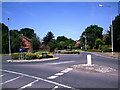
Roundabout at Langshott Housing Estate, Horley.
At junction of Smallfield Road and Wheatfield Way (in middle distance).
Image: © Rib
Taken: 11 Jul 2006
0.08 miles

3
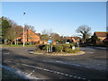
Roundabout on Smallfield Road at Wheatfield Way entrance to Langshott Estate, Horley, Surrey TQ291433
Image: © Richard Rogerson
Taken: 30 Jan 2010
0.12 miles
4
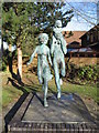
Sculpture at entrance to Langshott Estate, Horley, Surrey.
The sculpture, called ‘In The Park’, is a by Sydney Harpley RA. It was commissioned by Wates Homes, the builders of the estate. Originally it included a small dog at the feet of the family but in the way of all good things it was stolen many years ago!
Image: © Richard Rogerson
Taken: 30 Jan 2010
0.14 miles
5
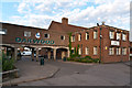
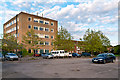
Oakwood School
Previously Horley County Secondary Modern School, the buildings here were started around 1953. In 1979 it merged with Court Lodge County Comprehensive School, receiving its current name. Now Horley's only secondary school.
Image: © Ian Capper
Taken: 13 Jun 2012
0.15 miles
6
Oakwood School
Previously Horley County Secondary Modern School, the buildings here were started around 1953. In 1979 it merged with Court Lodge County Comprehensive School, receiving its current name. Now Horley's only secondary school.
Image: © Ian Capper
Taken: 13 Jun 2012
0.16 miles
7
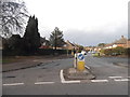
The Meadway at the junction of Smallfield Road
Image: © David Howard
Taken: 29 Mar 2015
0.17 miles
8
Oakwood School
Previously Horley County Secondary Modern School, the buildings here were started around 1953. In 1979 it merged with Court Lodge County Comprehensive School, receiving its current name. Now Horley's only secondary school.
Image: © Ian Capper
Taken: 13 Jun 2012
0.21 miles
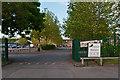
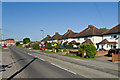
9
Horley: The Meadway
Post-war housing estate.
Image: © Nigel Cox
Taken: 18 Aug 2006
0.21 miles
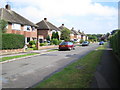
10
Smallfield Road
Looking towards where it meets Balcombe Road (in the background of this photo).
Image: © Ian Capper
Taken: 27 May 2013
0.23 miles