IMAGES TAKEN NEAR TO
Tyrell Way, RH6 8TX
Introduction
This page details the photographs taken nearby to Tyrell Way, RH6 8TX by members of the Geograph project.
The Geograph project started in 2005 with the aim of publishing, organising and preserving representative images for every square kilometre of Great Britain, Ireland and the Isle of Man.

There are currently over 7.5m images from over14,400 individuals and you can help contribute to the project by visiting https://www.geograph.org.uk
Image Map
Images are licensed for reuse under creativecommons.org/licenses/by-sa/2.0
Notes
- Clicking on the map will re-center to the selected point.
- The higher the marker number, the further away the image location is from the centre of the postcode.
Image Listing (4 Images Found)
Images are licensed for reuse under creativecommons.org/licenses/by-sa/2.0
Image
Details
Distance
1
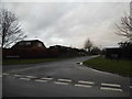
Bolters Road South at the junction of Kingsley Road
Image: © David Howard
Taken: 31 Jan 2016
0.18 miles
2
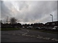
Meath Green Lane at the junction of Kingsley Road
Image: © David Howard
Taken: 31 Jan 2016
0.20 miles
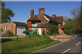
4
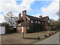
The Teddy Bear House, Horley
Currently for sale, this is a well known and well loved local landmark. Although rumoured to date back to the 16th century and believed to have originally been a Coaching Inn called "The Bear", the first reference found to the house is on a tithe map of 1848. A two storey wing was added in the early 1900s. It is known as the Teddy Bear House because of the teddy bears that live on the balcony. They wear different outfits depending on the weather.
Image: © Richard Rogerson
Taken: 10 Mar 2019
0.24 miles