IMAGES TAKEN NEAR TO
Gower Road, HORLEY, RH6 8SH
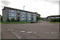
Introduction
This page details the photographs taken nearby to Gower Road, RH6 8SH by members of the Geograph project.
The Geograph project started in 2005 with the aim of publishing, organising and preserving representative images for every square kilometre of Great Britain, Ireland and the Isle of Man.

There are currently over 7.5m images from over14,400 individuals and you can help contribute to the project by visiting https://www.geograph.org.uk
Image Map
Images are licensed for reuse under creativecommons.org/licenses/by-sa/2.0
Notes
- Clicking on the map will re-center to the selected point.
- The higher the marker number, the further away the image location is from the centre of the postcode.
Image Listing (39 Images Found)
Images are licensed for reuse under creativecommons.org/licenses/by-sa/2.0
Image
Details
Distance
1

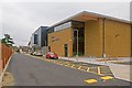
Horley Leisure Centre
The new Horley Leisure Centre, seen here the day before its opening, 9 January 2012. It has been built on the site of the former Court Lodge Secondary School and includes a 25m swimming pool, a sports hall and a fitness centre. Building work started in September 2010. It replaces the old Horley Anderson Centre (see Image) which was built in 1974.
Image: © Ian Capper
Taken: 8 Jan 2012
0.08 miles
2
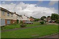
Court Lodge Road
Part of the Court Lodge Estate, built in 1965 for the then local council, Dorking and Horley RDC. The estate is named after Court Lodge Farm, which was situated next to the River Mole.
Image: © Ian Capper
Taken: 11 Sep 2011
0.08 miles
3
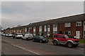
Court Lodge Road
Two blocks in Court Lodge Road, near its junction with Lee Street.
Image: © Ian Capper
Taken: 8 Jan 2012
0.09 miles
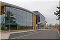
4

Horley Leisure Centre
The new Horley Leisure Centre, seen here the day before its opening, 9 January 2012. It has been built on the site of the former Court Lodge Secondary School and includes a 25m swimming pool, a sports hall and a fitness centre. Building work started in September 2010. It replaces the old Horley Anderson Centre (see Image) which was built in 1974.
Image: © Ian Capper
Taken: 8 Jan 2012
0.09 miles
5
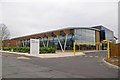
Horley Leisure Centre
The new Horley Leisure Centre, seen here the day before its opening, 9 January 2012. It has been built on the site of the former Court Lodge Secondary School and includes a 25m swimming pool, a sports hall and a fitness centre. Building work started in September 2010. It replaces the old Horley Anderson Centre (see Image) which was built in 1974.
Image: © Ian Capper
Taken: 8 Jan 2012
0.09 miles
6
Horley Leisure Centre
The new Horley Leisure Centre, seen here the day before its opening, 9 January 2012. It has been built on the site of the former Court Lodge Secondary School and includes a 25m swimming pool, a sports hall and a fitness centre. Building work started in September 2010. It replaces the old Horley Anderson Centre (see Image) which was built in 1974.
Image: © Ian Capper
Taken: 8 Jan 2012
0.09 miles
7
Horley Leisure Centre
The new Horley Leisure Centre, seen here the day before its opening, 9 January 2012. It has been built on the site of the former Court Lodge Secondary School and includes a 25m swimming pool, a sports hall and a fitness centre. Building work started in September 2010. It replaces the old Horley Anderson Centre (see Image) which was built in 1974.
Image: © Ian Capper
Taken: 8 Jan 2012
0.09 miles
8
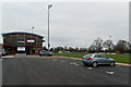
The New Defence
Home of Horley Town Football Club since 2003. The name of the ground is a carry over from the club's former ground in Smallfield Road, which had been donated to the town in 1947 by a local landowner, Major A L N Jennings, as a memorial to townspeople who had lost their lives in the Second World War.
Image: © Ian Capper
Taken: 8 Jan 2012
0.09 miles
9
Emlyn Road
Built in the early 1960s. The name is derived from an old name for the River Mole in Horley, the Emling or Emlyn Stream.
Image: © Ian Capper
Taken: 11 Sep 2011
0.11 miles
10
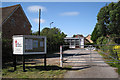
Lee Street Church (Independent Evangelical), Horley
Image: © Robin Stott
Taken: 31 Aug 2009
0.15 miles