IMAGES TAKEN NEAR TO
Court Lodge Road, HORLEY, RH6 8RR
Introduction
This page details the photographs taken nearby to Court Lodge Road, RH6 8RR by members of the Geograph project.
The Geograph project started in 2005 with the aim of publishing, organising and preserving representative images for every square kilometre of Great Britain, Ireland and the Isle of Man.

There are currently over 7.5m images from over14,400 individuals and you can help contribute to the project by visiting https://www.geograph.org.uk
Image Map
Images are licensed for reuse under creativecommons.org/licenses/by-sa/2.0
Notes
- Clicking on the map will re-center to the selected point.
- The higher the marker number, the further away the image location is from the centre of the postcode.
Image Listing (35 Images Found)
Images are licensed for reuse under creativecommons.org/licenses/by-sa/2.0
Image
Details
Distance
1
Lee Street Church (Independent Evangelical), Horley
Image: © Robin Stott
Taken: 31 Aug 2009
0.04 miles
2

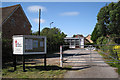
Horley Leisure Centre
The new Horley Leisure Centre, seen here the day before its opening, 9 January 2012. It has been built on the site of the former Court Lodge Secondary School and includes a 25m swimming pool, a sports hall and a fitness centre. Building work started in September 2010. It replaces the old Horley Anderson Centre (see Image) which was built in 1974.
Image: © Ian Capper
Taken: 8 Jan 2012
0.05 miles
3

Horley Leisure Centre
The new Horley Leisure Centre, seen here the day before its opening, 9 January 2012. It has been built on the site of the former Court Lodge Secondary School and includes a 25m swimming pool, a sports hall and a fitness centre. Building work started in September 2010. It replaces the old Horley Anderson Centre (see Image) which was built in 1974.
Image: © Ian Capper
Taken: 8 Jan 2012
0.05 miles
4

Horley Leisure Centre
The new Horley Leisure Centre, seen here the day before its opening, 9 January 2012. It has been built on the site of the former Court Lodge Secondary School and includes a 25m swimming pool, a sports hall and a fitness centre. Building work started in September 2010. It replaces the old Horley Anderson Centre (see Image) which was built in 1974.
Image: © Ian Capper
Taken: 8 Jan 2012
0.05 miles
5
Mill Close
Junction of Mill Close with Lee Street. On the left is part of Lee Street Burial Ground (see Image).
Image: © Ian Capper
Taken: 3 Apr 2011
0.06 miles
6
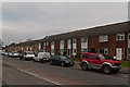
Court Lodge Road
Two blocks in Court Lodge Road, near its junction with Lee Street.
Image: © Ian Capper
Taken: 8 Jan 2012
0.06 miles
7

Horley Leisure Centre
The new Horley Leisure Centre, seen here the day before its opening, 9 January 2012. It has been built on the site of the former Court Lodge Secondary School and includes a 25m swimming pool, a sports hall and a fitness centre. Building work started in September 2010. It replaces the old Horley Anderson Centre (see Image) which was built in 1974.
Image: © Ian Capper
Taken: 8 Jan 2012
0.06 miles
8
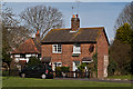
Lee Street
Two cottages in Lee Street. On the left is The Old House, a grade II listed house dating from the 16th century - see www.historicengland.org.uk/listing/the-list/list-entry/1295115.
Image: © Ian Capper
Taken: 3 Apr 2011
0.06 miles
9
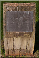
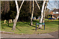
Plaque, Lee Street Burial Ground
Plaque giving history of Lee Street Burial Ground.
It reads:
"LEE STREET BURIAL GROUND
In 1846 six members of the Strict and Particular Baptists built a chapel at the southern end of this site.
The remainder of the site was used as a burial ground for worshippers at the chapel and commenced with the burial of Emma Pollard on 6 June 1852. The last burial was that of Jessie Nicol Jones on 14 November 1969.
In November 1994 Reigate and Banstead Borough Council acquired the site and designated it as a garden of remembrance for those buried here to enable their decendants (sic), relatives and friends to sit and remember them."
Image: © Ian Capper
Taken: 3 Apr 2011
0.07 miles
10
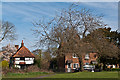
Lee Street
Two cottages in Lee Street. On the left is The Old House, a grade II listed house dating from the 16th century - see www.historicengland.org.uk/listing/the-list/list-entry/1295115.
Image: © Ian Capper
Taken: 3 Apr 2011
0.07 miles