IMAGES TAKEN NEAR TO
Cambridge Lodge Park, Bonehurst Road, HORLEY, RH6 8PR
Introduction
This page details the photographs taken nearby to Cambridge Lodge Park, Bonehurst Road, RH6 8PR by members of the Geograph project.
The Geograph project started in 2005 with the aim of publishing, organising and preserving representative images for every square kilometre of Great Britain, Ireland and the Isle of Man.

There are currently over 7.5m images from over14,400 individuals and you can help contribute to the project by visiting https://www.geograph.org.uk
Image Map
Images are licensed for reuse under creativecommons.org/licenses/by-sa/2.0
Notes
- Clicking on the map will re-center to the selected point.
- The higher the marker number, the further away the image location is from the centre of the postcode.
Image Listing (15 Images Found)
Images are licensed for reuse under creativecommons.org/licenses/by-sa/2.0
Image
Details
Distance
1
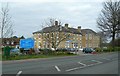
The Cambridge Hotel
One of many hotels in this area which cater for people travelling via Gatwick Airport.
Image: © Mary and Angus Hogg
Taken: 6 Mar 2008
0.07 miles
2
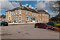
The Cambridge Hotel
Originally called Cambridge Lodge, it was built in 1850 by George, 2nd Duke of Cambridge, occupying the site of the former Kings Head public house. It is now a hotel. Primarily due to its historic connections it is grade II listed - see www.historicengland.org.uk/listing/the-list/list-entry/1028996.
Image: © Ian Capper
Taken: 22 Apr 2012
0.10 miles
3
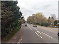
A23 Bonehurst Road
Looking north, with Bonehurst Bridge over the Burstow Stream ahead, the brick parapet shows on the right.
Image: © Robin Webster
Taken: 23 Mar 2019
0.12 miles
4
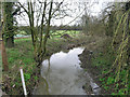
Burstow Stream at Bonehurst Bridge
Bonehurst Bridge, the viewpoint, carries the A23.
Image: © Robin Webster
Taken: 25 Mar 2010
0.13 miles
5
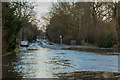
Bonehurst Road flood
23 December 2013 saw substantial rainfall in East Surrey as a major storm crossed Southern England. The result was some of the worst flooding in the area for many years taking place on Christmas Eve, particularly around Horley where the clay soil, already saturated from rain a few days earlier, was unable to absorb extra water, resulting in the various streams in the area overflowing, along with the River Mole, with areas close to the river further downstream, such as at Brockham, Pixham, Burford Bridge and Leatherhead, also being successively inundated. All roads between Reigate/Redhill and Horley were blocked by flood water. This is the A23 Bonehurst Road in Horley the following day, where it crosses the Burstow Stream (the bridge in the centre of the photo). The waters here have receded significantly since the previous day, Christmas Eve, when at around 4.00 the whole road was flooded up to beyond the bollard opposite the bus stop, and water could be seen pouring onto the road alongside the bridge parapet, with even the raised centre of the road being flooded to a depth of at least a foot.
Image: © Ian Capper
Taken: 25 Dec 2013
0.13 miles
6
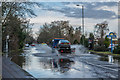
Bonehurst Road flood
23 December 2013 saw substantial rainfall in East Surrey as a major storm crossed Southern England. The result was some of the worst flooding in the area for many years taking place on Christmas Eve, particularly around Horley where the clay soil, already saturated from rain a few days earlier, was unable to absorb extra water, resulting in the various streams in the area overflowing, along with the River Mole, with areas close to the river further downstream, such as at Brockham, Pixham, Burford Bridge and Leatherhead, also being successively inundated. All roads between Reigate/Redhill and Horley were blocked by flood water. This is the A23 Bonehurst Road in Horley the following day, where it crosses the Burstow Stream (see Image for closer view). The waters here have receded significantly since the previous day, Christmas Eve, when at around 4.00 the whole road was flooded up to beyond the cars parked in the distance, and water could be seen pouring onto the road alongside the parapet of the bridge over the stream, with even the raised centre of the road being flooded to a depth of at least a foot.
Image: © Ian Capper
Taken: 25 Dec 2013
0.15 miles
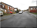
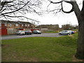
7
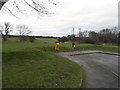
Park at the end of Kingsley Road
The line by the trees is the Burstow Stream
Image: © David Howard
Taken: 31 Jan 2016
0.15 miles
8
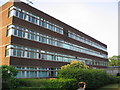
Philips Research Campus Redhill
The campus is off Cross Oak Lane, salfords, Surrey
Image: © Richard Rogerson
Taken: 30 Jun 2006
0.18 miles