IMAGES TAKEN NEAR TO
Denshire Field, HORLEY, RH6 8GU
Introduction
This page details the photographs taken nearby to Denshire Field, RH6 8GU by members of the Geograph project.
The Geograph project started in 2005 with the aim of publishing, organising and preserving representative images for every square kilometre of Great Britain, Ireland and the Isle of Man.

There are currently over 7.5m images from over14,400 individuals and you can help contribute to the project by visiting https://www.geograph.org.uk
Image Map
Images are licensed for reuse under creativecommons.org/licenses/by-sa/2.0
Notes
- Clicking on the map will re-center to the selected point.
- The higher the marker number, the further away the image location is from the centre of the postcode.
Image Listing (15 Images Found)
Images are licensed for reuse under creativecommons.org/licenses/by-sa/2.0
Image
Details
Distance
1
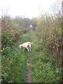
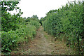
Public Footpath leading to footbridge over the River Mole, just North west of Horley, Surrey
Image: © Richard Rogerson
Taken: 11 Nov 2009
0.11 miles
2
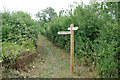
Footpath junction, Meath Green, 2010
Footpath 362c branches left off footpath 411 Horley. This spot is now in the middle of housing estates and the route left, formerly straight, joggles along housing estate roads.
Image: © Robin Webster
Taken: 18 Jul 2010
0.15 miles
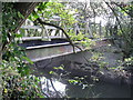
3
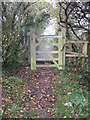
Footbridge over the River Mole near Horley Surrey
Image: © Richard Rogerson
Taken: 11 Nov 2009
0.16 miles
4
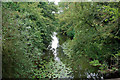
River Mole, looking upstream
Ever a pleasant river, well filled, even in a dry summer, with treated effluent for thirsty Londoners.
Image: © Robin Webster
Taken: 18 Jul 2010
0.16 miles
5
Footpath 411 Horley, 2010
Towards the River Mole, Moat Farm and Reigate Road.
Image: © Robin Webster
Taken: 18 Jul 2010
0.16 miles
6
Footbridge over The River Mole near Horley
Image: © Richard Rogerson
Taken: 9 Oct 2009
0.17 miles
7
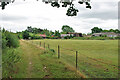
Field by footpath 411 Horley, 2010
The field is now part of a housing estate. Across the field is Landens Farm.
Image: © Robin Webster
Taken: 18 Jul 2010
0.17 miles
8
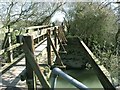
Footbridge over River Mole
This is a small, well maintained footbridge over the river mole in rural countryside. The supports suggest that a wider bridge once traversed the river here, something that is confirmed by older maps where a track once led along this route.
Image: © Hywel Williams
Taken: 5 Apr 2006
0.18 miles
9
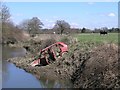
Derelict car on river bend
A derelict car lies on the bend of the River Mole.
Image: © Hywel Williams
Taken: 5 Apr 2006
0.18 miles
10
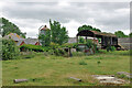
Landens Farm, Meath Green, 2010
Now mostly demolished with the stable block converted to housing, and surrounded by housing.
Image: © Robin Webster
Taken: 18 Jul 2010
0.19 miles