IMAGES TAKEN NEAR TO
Hurst Road, HORLEY, RH6 8EJ
Introduction
This page details the photographs taken nearby to Hurst Road, RH6 8EJ by members of the Geograph project.
The Geograph project started in 2005 with the aim of publishing, organising and preserving representative images for every square kilometre of Great Britain, Ireland and the Isle of Man.

There are currently over 7.5m images from over14,400 individuals and you can help contribute to the project by visiting https://www.geograph.org.uk
Image Map
Images are licensed for reuse under creativecommons.org/licenses/by-sa/2.0
Notes
- Clicking on the map will re-center to the selected point.
- The higher the marker number, the further away the image location is from the centre of the postcode.
Image Listing (38 Images Found)
Images are licensed for reuse under creativecommons.org/licenses/by-sa/2.0
Image
Details
Distance
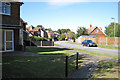
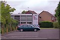
1
Hurst Road
Road of Edwardian cottages off Lee Street.
Image: © Ian Capper
Taken: 27 May 2013
0.00 miles
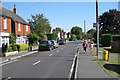
2
Lee Street Church
An independent evangelical church on Lee Street.
Image: © Ian Capper
Taken: 4 Sep 2011
0.08 miles
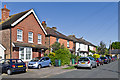
3
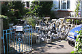
Garden gnomes for sale, Lee Street, Horley
Image: © Robin Stott
Taken: 31 Aug 2009
0.10 miles
5
Lee Street Church (Independent Evangelical), Horley
Image: © Robin Stott
Taken: 31 Aug 2009
0.13 miles
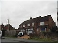
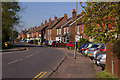
6
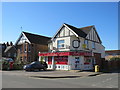
A Corner Shop in Horley
One of many that has stayed open and is doing a great job serving local customers during the Coronavirus.
Image: © Richard Rogerson
Taken: 5 Apr 2020
0.14 miles
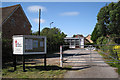
7
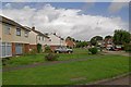
Emlyn Road
Built in the early 1960s. The name is derived from an old name for the River Mole in Horley, the Emling or Emlyn Stream.
Image: © Ian Capper
Taken: 11 Sep 2011
0.15 miles