IMAGES TAKEN NEAR TO
Ashleigh Close, HORLEY, RH6 8AJ
Introduction
This page details the photographs taken nearby to Ashleigh Close, RH6 8AJ by members of the Geograph project.
The Geograph project started in 2005 with the aim of publishing, organising and preserving representative images for every square kilometre of Great Britain, Ireland and the Isle of Man.

There are currently over 7.5m images from over14,400 individuals and you can help contribute to the project by visiting https://www.geograph.org.uk
Image Map
Images are licensed for reuse under creativecommons.org/licenses/by-sa/2.0
Notes
- Clicking on the map will re-center to the selected point.
- The higher the marker number, the further away the image location is from the centre of the postcode.
Image Listing (93 Images Found)
Images are licensed for reuse under creativecommons.org/licenses/by-sa/2.0
Image
Details
Distance
1
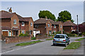
Sangers Drive
1950s housing in a road named after George Sanger, who with his brother founded a circus in 1953 which was based in Horley.
Image: © Ian Capper
Taken: 26 May 2013
0.05 miles
2
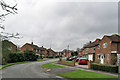
Sangers Drive, Horley
To the right it parallels the A23, but is not directly accessible from it, except on foot.
Image: © Robin Webster
Taken: 25 Mar 2010
0.05 miles
3
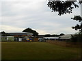
Playing field and school buildings at Manorfield Primary School Horley
Image: © Rod Allday
Taken: 10 Jul 2015
0.07 miles
5
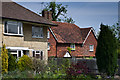
Contrasting houses
1960s maisonettes at the junction of Church Road with Brighton Road, alongside 53 Brighton Road (Ringley Oak Cottage), a grade II listed building dating from the 17th century but built around a hall house dating from around 1500 - for listing particulars see www.historicengland.org.uk/listing/the-list/list-entry/1029022.
Image: © Ian Capper
Taken: 26 May 2013
0.10 miles
6
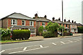
Brighton Road
Villas in Brighton Road, dating from around the turn of the 19th/20th century.
Image: © Ian Capper
Taken: 2 Jul 2013
0.10 miles
7
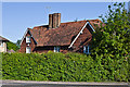
Ringley Oak Cottage
Ringley Oak Cottage, a grade II listed building dating from the 17th century but built around a hall house dating from around 1500 - for listing particulars see www.historicengland.org.uk/listing/the-list/list-entry/1029022.
For another angle see Image
Image: © Ian Capper
Taken: 27 May 2013
0.10 miles
8
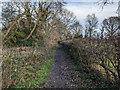
Footpath 384, Horley
The cemetery is on the right.
Image: © Robin Webster
Taken: 9 Jan 2023
0.10 miles
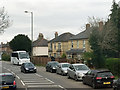
9
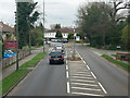
A23 Brighton Road, Horley
Looking north.
Image: © Robin Webster
Taken: 23 Mar 2019
0.11 miles
10
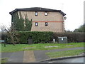
Block of flats by Sangers Drive, Horley
The front is on Court Lodge Road
Image: © David Howard
Taken: 31 Jan 2016
0.11 miles