IMAGES TAKEN NEAR TO
The Ridgeway, HORLEY, RH6 7NN
Introduction
This page details the photographs taken nearby to The Ridgeway, RH6 7NN by members of the Geograph project.
The Geograph project started in 2005 with the aim of publishing, organising and preserving representative images for every square kilometre of Great Britain, Ireland and the Isle of Man.

There are currently over 7.5m images from over14,400 individuals and you can help contribute to the project by visiting https://www.geograph.org.uk
Image Map
Images are licensed for reuse under creativecommons.org/licenses/by-sa/2.0
Notes
- Clicking on the map will re-center to the selected point.
- The higher the marker number, the further away the image location is from the centre of the postcode.
Image Listing (40 Images Found)
Images are licensed for reuse under creativecommons.org/licenses/by-sa/2.0
Image
Details
Distance
3
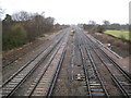
Gatwick: Main London to Brighton railway line
Viewed looking towards Horley station from the footbridge north of Gatwick Airport station, Stephen's Image, with its prominent chimney at either end, is just visible in the distance. The railway has been here since 1841.
As an aside looking at the 1879 Edition of the Ordnance Survey map some text has been added in the vicinity that says:
"British Sepulchral Urn, Flint Arrow Heads, and Bronze Roman Coins found here."
Perhaps they were found during the construction of the railway.
Image: © Nigel Cox
Taken: 19 Jan 2009
0.16 miles
4

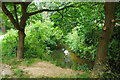
Gatwick Stream, Riverside Garden Park, Horley
Looking upstream.
Image: © Robin Webster
Taken: 7 Jul 2010
0.16 miles
5
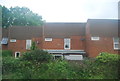
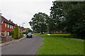
The Crescent
Originally laid out in the 1930s but largely developed post World War II.
Image: © Ian Capper
Taken: 27 May 2012
0.17 miles
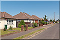
6
Riverside
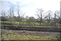
Housing alongside the Gatwick Stream, some of it built for the local council in the late 1950s/early 1960s.
Image: © Ian Capper
Taken: 5 Jul 2012
0.18 miles
7
The Crescent
Originally laid out in the 1930s but largely developed post World War II.
Image: © Ian Capper
Taken: 27 May 2012
0.18 miles
8
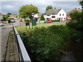
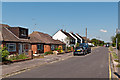
Looking into Riverside from the bridge over Gatwick Stream
Behind the camera is the parking area in Riverside Garden Park.
See also http://www.geograph.org.uk/photo/3314351. This is in Surrey.
Image: © Shazz
Taken: 2 Jun 2016
0.18 miles
9
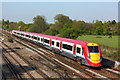
Railway near Gatwick Airport
Gatwick Express approaching its destination.
Image: © Wayland Smith
Taken: 18 Apr 2009
0.18 miles
10
Gatwick Stream, Riverside Garden Park, Horley
Looking downstream.
Image: © Robin Webster
Taken: 7 Jul 2010
0.19 miles