IMAGES TAKEN NEAR TO
The Drive, HORLEY, RH6 7JP
Introduction
This page details the photographs taken nearby to The Drive, RH6 7JP by members of the Geograph project.
The Geograph project started in 2005 with the aim of publishing, organising and preserving representative images for every square kilometre of Great Britain, Ireland and the Isle of Man.

There are currently over 7.5m images from over14,400 individuals and you can help contribute to the project by visiting https://www.geograph.org.uk
Image Map
Images are licensed for reuse under creativecommons.org/licenses/by-sa/2.0
Notes
- Clicking on the map will re-center to the selected point.
- The higher the marker number, the further away the image location is from the centre of the postcode.
Image Listing (72 Images Found)
Images are licensed for reuse under creativecommons.org/licenses/by-sa/2.0
Image
Details
Distance
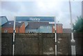
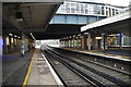
4
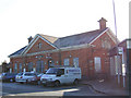
Horley Railway Station, Surrey
It opened 31 December 1905, to coincide with the quadrupling of the railway line by the London Brighton and South Coast Railway
Image: © Richard Rogerson
Taken: 6 Jan 2010
0.03 miles
6
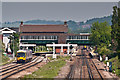
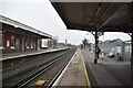
Horley Station
The heat haze is apparent in this telephoto view of Horley Station, with Class 166 DMU no 166 205 running north on the 11.08 Gatwick to Reading service.
Image: © Ian Capper
Taken: 27 May 2012
0.04 miles
8
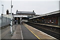
Horley railway station, Surrey
Opened in 1906 by the London Brighton & South Coast Railway on the line from Croydon to Three Bridges, this station replaced an earlier one that had been around 300m further north.
View north towards Salfords and Croydon.
Image: © Nigel Thompson
Taken: 6 Nov 2015
0.04 miles
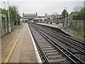
10
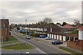
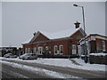
The Drive
Looking along The Drive from the incline of Victoria Road as it crosses the railway at Horley Station.
The road was laid out in the mid 1930s, with further subsequent building. A 1912 map shows a Spear's Farm on this site.
In the background can be seen the South Terminal Building at Gatwick Airport.
Image: © Ian Capper
Taken: 9 Mar 2010
0.04 miles