IMAGES TAKEN NEAR TO
Lumley Road, HORLEY, RH6 7JF
Introduction
This page details the photographs taken nearby to Lumley Road, RH6 7JF by members of the Geograph project.
The Geograph project started in 2005 with the aim of publishing, organising and preserving representative images for every square kilometre of Great Britain, Ireland and the Isle of Man.

There are currently over 7.5m images from over14,400 individuals and you can help contribute to the project by visiting https://www.geograph.org.uk
Image Map
Images are licensed for reuse under creativecommons.org/licenses/by-sa/2.0
Notes
- Clicking on the map will re-center to the selected point.
- The higher the marker number, the further away the image location is from the centre of the postcode.
Image Listing (117 Images Found)
Images are licensed for reuse under creativecommons.org/licenses/by-sa/2.0
Image
Details
Distance
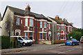
1
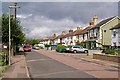
Albert Road
One of the earliest residential roads in Horley, dating from the mid 19th century after the arrival of the railway in the town.
Image: © Ian Capper
Taken: 18 Sep 2011
0.05 miles
2
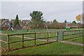
Yattendon Road Playground
A playground in a recreation ground at the end of Yattendon Road.
Image: © Ian Capper
Taken: 7 Nov 2010
0.06 miles
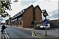
3
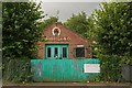
Horley Forge
Now occupied by a plumbing company.
Image: © Ian Capper
Taken: 18 Sep 2011
0.06 miles
4
Albert Road
One of the earliest residential roads in Horley, dating from the mid 19th century after the arrival of the railway in the town.
Image: © Ian Capper
Taken: 18 Sep 2011
0.06 miles
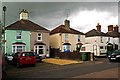
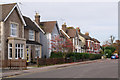
5
Yattendon Road
Late Victorian villas in Yattendon Road. The date plaques on them give a year of 1891.
Image: © Ian Capper
Taken: 7 Nov 2010
0.07 miles
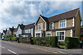
6
Yattendon Road
Late Victorian villas in Yattendon Road
Image: © Ian Capper
Taken: 7 Nov 2010
0.07 miles
7
Yattendon Road
Late Victorian villas in Yattendon Road.
Image: © Ian Capper
Taken: 2 Aug 2015
0.07 miles
9
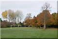
Yattendon Road Recreation Ground
A small green space at the end of Yattendon Road.
Image: © Ian Capper
Taken: 7 Nov 2010
0.08 miles
10
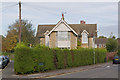
Woodbourne
A care home at the junction of Oakwood Road with Yattendon Road.
Image: © Ian Capper
Taken: 7 Nov 2010
0.08 miles