
IMAGES TAKEN NEAR TO
Longbridge Road, HORLEY, RH6 7EL
Introduction
This page details the photographs taken nearby to Longbridge Road, RH6 7EL by members of the Geograph project.
The Geograph project started in 2005 with the aim of publishing, organising and preserving representative images for every square kilometre of Great Britain, Ireland and the Isle of Man.

There are currently over 7.5m images from over14,400 individuals and you can help contribute to the project by visiting https://www.geograph.org.uk
Image Map
Images are licensed for reuse under creativecommons.org/licenses/by-sa/2.0
Notes
- Clicking on the map will re-center to the selected point.
- The higher the marker number, the further away the image location is from the centre of the postcode.
Image Listing (88 Images Found)
Images are licensed for reuse under creativecommons.org/licenses/by-sa/2.0
Image
Details
Distance
1
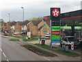
A23 Brighton Road, Horley, east side
The houses are on a parallel service road, Church Walk.
Image: © Robin Webster
Taken: 23 Mar 2019
0.05 miles
2
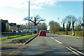
A23 Brighton Road, Horley
Heading south.
Image: © Robin Webster
Taken: 7 Feb 2018
0.08 miles
3
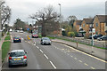
A23 Brighton Road, Horley
Looking north.
Image: © Robin Webster
Taken: 23 Mar 2019
0.10 miles
4
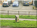
Milestone, A23 Brighton Road, Horley
26 miles to Brighton, 25 to Westminster, but the Brighton distance is altered these days by deviations around Gatwick Airport and at various points to the south.
Image: © Robin Webster
Taken: 23 Mar 2019
0.10 miles
5
Milepost, Brighton Road
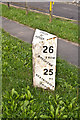
Close up of the cast iron milepost in Image This of a standard design for mileposts along this route, which was built in 1816 as a direct route from Gatton Point, north of Redhill, to Povey Cross, near Gatwick.
The post shows the distances to/from Brighton and Westminster Bridge on the two faces, but in a different order according to the direction of travel. On the top face is the locality (here the Parish of Horley).
Image: © Ian Capper
Taken: 13 Jun 2012
0.10 miles
6
Old Milepost by the A23, Brighton Road, Horley parish
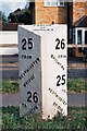
Cast iron post by the A23, in parish of Horley (Reigate and Banstead District), Brighton Road, opposite parish church, Northeast of Longbridge roundabout, on the verge between pavement and road, on East side of road. Reigate iron casting, erected by the Gatton Lodge to Povey Cross turnpike trust in the 19th century.
Inscription reads:-
: 25 / FROM / WESTMINSTER / BRIDGE / 26 / TO / BRIGHTON : : PARISH / OF / HORLEY : : 26 / FROM / BRIGHTON / 25 / TO / WESTMINSTER / BRIDGE :
Milestone Society National ID: SY_LBT25
Image: © JS Payne
Taken: 1 Sep 2007
0.10 miles
7
No Entry
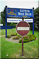
Pre-Worboys No entry sign outside the Gatwick Moat House (since rebranded as the Airport Inn). Note the embossed "NO ENTRY" in the central white strip. For a full view of the hotel see Image
Image: © Ian Capper
Taken: 2 Jul 2013
0.11 miles
8
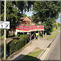
Reroofing of lych gate, Horley churchyard
Image: © Robin Webster
Taken: 2 Oct 2019
0.11 miles
9
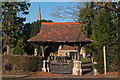
Lychgate, St Bartholomew's Church, Horley
Lychgate for St Bartholomew's Church (see Image). The lychgate dates from 1903, built by Arthur Jennings, and commemorates those killed in the Boer War - a carved inscription on the south side reads "To the glory of God and in memory of our fellow parishioners who fell in the South African War 1899-1902", with their names (A W Carling, C C Sargent, and J T Turnbull) inscribed on both sides of the lychgate, along with those of the Vicar and Churchwardens at the time (Rev H T Lewis, B W Parsons and F T Glover). It is grade Ic listed.
In the background can be seen the spire of the church.
Image: © Ian Capper
Taken: 22 Jan 2012
0.11 miles
10
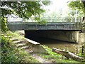
A23 bridge over the River Mole
The A23 (London Road) here crosses the River Mole. The path in view is part of the Millennium Trail, a circular walk which follows the Gatwick Stream through the Riverside Garden Park before returning along the distinctly unappealing footway alongside the A23 for a kilometre or so.
Image: © Oliver Dixon
Taken: 28 Sep 2013
0.11 miles