IMAGES TAKEN NEAR TO
Yattendon Road, HORLEY, RH6 7BS
Introduction
This page details the photographs taken nearby to Yattendon Road, RH6 7BS by members of the Geograph project.
The Geograph project started in 2005 with the aim of publishing, organising and preserving representative images for every square kilometre of Great Britain, Ireland and the Isle of Man.

There are currently over 7.5m images from over14,400 individuals and you can help contribute to the project by visiting https://www.geograph.org.uk
Image Map
Images are licensed for reuse under creativecommons.org/licenses/by-sa/2.0
Notes
- Clicking on the map will re-center to the selected point.
- The higher the marker number, the further away the image location is from the centre of the postcode.
Image Listing (120 Images Found)
Images are licensed for reuse under creativecommons.org/licenses/by-sa/2.0
Image
Details
Distance
1
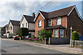
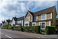
Yattendon Road
Late Victorian cottages in Yattendon Road.
Image: © Ian Capper
Taken: 2 Aug 2015
0.00 miles
2
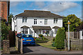
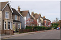
Montreal Cottages
Late Victorian semi-detached cottages in Yattendon Road. Unlike its neighbours, this building is set back from the road.
Image: © Ian Capper
Taken: 2 Aug 2015
0.01 miles
3
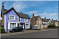
Yattendon Road
Late Victorian villas in Yattendon Road.
Image: © Ian Capper
Taken: 2 Aug 2015
0.02 miles
4
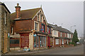
Yattendon Road
Late Victorian development near its junction with High Street, previously Station Road at its former crossing point of the railway (see Image). The building on the left is a former post office - see Image
Image: © Ian Capper
Taken: 20 Nov 2011
0.04 miles
5
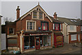
Former post office, Yattendon Road
Former post office, shown as such on the 1896 large scale map. Now a motor parts shop.
Image: © Ian Capper
Taken: 20 Nov 2011
0.04 miles
6
Yattendon Road
Late Victorian villas in Yattendon Road.
Image: © Ian Capper
Taken: 2 Aug 2015
0.04 miles
7
Yattendon Road
Late Victorian villas in Yattendon Road
Image: © Ian Capper
Taken: 7 Nov 2010
0.05 miles
8
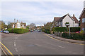
Oakwood Road
Looking along Oakwood Road from its junction with Yattendon Road (which despite the road markings runs right to left across the foreground). The signpost is to Yattendon Road Recreation Ground - see Image and Image
Image: © Ian Capper
Taken: 7 Nov 2010
0.05 miles
9

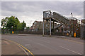
Footbridge near site of former Horley Station
This footbridge crosses the London to Brighton railway line and links High Street (in the foreground, with Yattendon Road off to the left) and Station Road. Until 1903, the road (then called Station Road throughout) crossed the railway at a level crossing, with the 1841 Horley Station immediately to the south. The quadrupling of the railway in 1905 led to the crossing being severed and replaced by a subway, with this footbridge being added later. At the same time the station was moved around 300 metres to the south, with a station building on a new Victoria Road overbridge (this too had previously crossed the railway at a level crossing), as seen in the background in Image
Image: © Ian Capper
Taken: 25 Jul 2009
0.05 miles
10
Footbridge near site of former Horley Station
This footbridge crosses the London to Brighton railway line and links Station Road (in the foreground, turning into Station Approach on the left) and High Street (beyond the bridge). Until 1903, the road (then called Station Road throughout) crossed the railway at a level crossing, with the 1841 Horley Station immediately to the south. The quadrupling of the railway in 1905 led to the crossing being severed and replaced by a subway (the entrance to which can be seen to the left of the photo), with this footbridge being added later. At the same time the station was moved around 300 metres to the south, with a station building on a new Victoria Road overbridge (this too had previously crossed the railway at a level crossing), as seen in the background in Image
Image: © Ian Capper
Taken: 25 Jul 2009
0.05 miles