IMAGES TAKEN NEAR TO
Nursery Lane, HORLEY, RH6 0HG
Introduction
This page details the photographs taken nearby to Nursery Lane, RH6 0HG by members of the Geograph project.
The Geograph project started in 2005 with the aim of publishing, organising and preserving representative images for every square kilometre of Great Britain, Ireland and the Isle of Man.

There are currently over 7.5m images from over14,400 individuals and you can help contribute to the project by visiting https://www.geograph.org.uk
Image Map
Images are licensed for reuse under creativecommons.org/licenses/by-sa/2.0
Notes
- Clicking on the map will re-center to the selected point.
- The higher the marker number, the further away the image location is from the centre of the postcode.
Image Listing (20 Images Found)
Images are licensed for reuse under creativecommons.org/licenses/by-sa/2.0
Image
Details
Distance
3
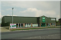
Fairalls
A building merchants in new premises opened in 2011, on the site of a former car dealership.
Image: © Ian Capper
Taken: 23 Apr 2011
0.10 miles
4
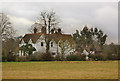
Hookwood Lodge
A Victorian house, now a hotel.
Image: © Ian Capper
Taken: 13 Mar 2010
0.11 miles
6
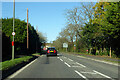
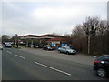
A217 Reigate Road, Hookwood
Towards Reigate.
Image: © Robin Webster
Taken: 18 Nov 2022
0.13 miles
9
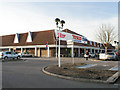
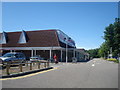
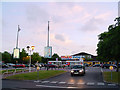
Tesco extra
Now open 24 hours! Which, apparently, it was not in 2005 according to the sign Image I'm not sure why the little white gables were originally added to the roof but the one in front of the sign appears to have gone.
Image: © Andy Potter
Taken: 27 Jan 2008
0.16 miles