IMAGES TAKEN NEAR TO
Stan Hill, HORLEY, RH6 0ES
Introduction
This page details the photographs taken nearby to Stan Hill, RH6 0ES by members of the Geograph project.
The Geograph project started in 2005 with the aim of publishing, organising and preserving representative images for every square kilometre of Great Britain, Ireland and the Isle of Man.

There are currently over 7.5m images from over14,400 individuals and you can help contribute to the project by visiting https://www.geograph.org.uk
Image Map
Images are licensed for reuse under creativecommons.org/licenses/by-sa/2.0
Notes
- Clicking on the map will re-center to the selected point.
- The higher the marker number, the further away the image location is from the centre of the postcode.
Image Listing (14 Images Found)
Images are licensed for reuse under creativecommons.org/licenses/by-sa/2.0
Image
Details
Distance
1
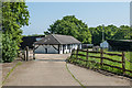
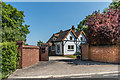
Crafts U Love
Sellers of card craft components and tools housed in a building on Westcoats Farm.
Image: © Ian Capper
Taken: 20 May 2018
0.07 miles
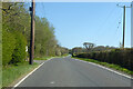
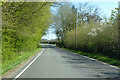
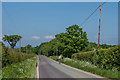
6
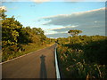
Straight road pointing south-east up Stan Hill
Long straight road pointing south-east up Stan Hill towards Highworth Farm. Wow - newly laid road surface!
Image: © James Insell
Taken: 6 Jul 2005
0.11 miles
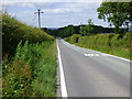
8
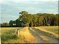
Stan Hill
Road connecting Charlwood and Newdigate, becoming Blanks Lane further along.
Image: © Ian Capper
Taken: 20 May 2018
0.13 miles
9
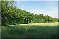
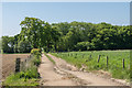
North of Ricketts Wood
Looking from the boundary of the Woodland Trust property across the corner of a field of rape at a belt of woodland between fields. The woodland, although narrow, is rather more than an overgrown hedge. It extends for some distance north, a useful corridor for wildlife. Such woodland belts between fields are a common feature in this area of the Low Weald.
Image: © Robin Webster
Taken: 25 Jun 2010
0.13 miles