IMAGES TAKEN NEAR TO
Norwood Hill Road, HORLEY, RH6 0EB
Introduction
This page details the photographs taken nearby to Norwood Hill Road, RH6 0EB by members of the Geograph project.
The Geograph project started in 2005 with the aim of publishing, organising and preserving representative images for every square kilometre of Great Britain, Ireland and the Isle of Man.

There are currently over 7.5m images from over14,400 individuals and you can help contribute to the project by visiting https://www.geograph.org.uk
Image Map
Images are licensed for reuse under creativecommons.org/licenses/by-sa/2.0
Notes
- Clicking on the map will re-center to the selected point.
- The higher the marker number, the further away the image location is from the centre of the postcode.
Image Listing (6 Images Found)
Images are licensed for reuse under creativecommons.org/licenses/by-sa/2.0
Image
Details
Distance
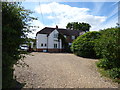
1
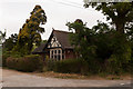
Edolph Lodge
Former lodge on Norwoodhill Road.
Image: © Ian Capper
Taken: 4 Jun 2011
0.01 miles
3
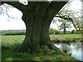
Old Oak next to Pond at Edolphs Farm
Taken from public footpath
Image: © James Insell
Taken: 21 Apr 2002
0.06 miles
5
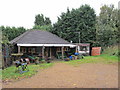
Endolphs Farm (former ) Shop
A source of local produce especially meat, but now sadly closed.
Image: © Richard Rogerson
Taken: 26 Oct 2013
0.12 miles
6
1, Charlwood Place Cottages
On Norwoodhill Road.
Image: © Dr Neil Clifton
Taken: 27 Jun 2015
0.21 miles