IMAGES TAKEN NEAR TO
Crocknorth Road, DORKING, RH5 6SZ
Introduction
This page details the photographs taken nearby to Crocknorth Road, RH5 6SZ by members of the Geograph project.
The Geograph project started in 2005 with the aim of publishing, organising and preserving representative images for every square kilometre of Great Britain, Ireland and the Isle of Man.

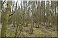
There are currently over 7.5m images from over14,400 individuals and you can help contribute to the project by visiting https://www.geograph.org.uk
Image Map
Images are licensed for reuse under creativecommons.org/licenses/by-sa/2.0
Notes
- Clicking on the map will re-center to the selected point.
- The higher the marker number, the further away the image location is from the centre of the postcode.
Image Listing (21 Images Found)
Images are licensed for reuse under creativecommons.org/licenses/by-sa/2.0
Image
Details
Distance
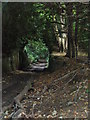
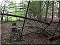
2
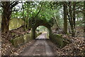
Hermitage Arch
Brick archway in a very secluded "Lovelace Bridge". The old forest track above is private, it leads to the Hermitage.
Image: © Colin Smith
Taken: 9 Sep 2007
0.02 miles
3
Hermitage Arch, Lovelace Bridge
This secluded flint-walled bridge is very difficult to photograph as it is very obscured by the summer foliage. The flint abutments flanking the bridleway are more easily seen.
Image: © Colin Smith
Taken: 9 Sep 2007
0.02 miles
4
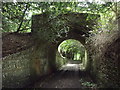
Hermitage Arch
One of the Victorian brick and flint logging Lovelace Bridges. This one spans Sheepwalk Lane, an old drove road.
http://www.geograph.org.uk/article/East-Horsleys-Lovelace-Bridges-Trail
Image: © Colin Smith
Taken: 17 Jun 2012
0.02 miles
5
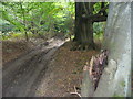
Byway to the Hermitage.
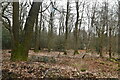
Deep wheel ruts in the North Downs clay appear near the aptly named Hermitage - it is remote.
Image: © Colin Smith
Taken: 9 Sep 2007
0.06 miles
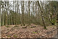
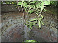
7
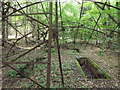
Underneath the Arches
Four shallow brick-lined pits lie beneath the fallen arches which perhaps once supported a nissen hut. There are rusting nissen huts nearby, maybe a WW2 campsite? Perhaps these pits were used in forestry activities?
Image: © Colin Smith
Taken: 17 Jun 2012
0.08 miles
8
Old Pits, Sheepwalk Lane
Four shallow and brick-lined pits lie beneath a collapsed iron arched-roof framework. Perhaps these were WW2 sawpits? Rusting nissen huts are nearby.
Image: © Colin Smith
Taken: 17 Jun 2012
0.09 miles