IMAGES TAKEN NEAR TO
Ranmore Common, DORKING, RH5 6SR
Introduction
This page details the photographs taken nearby to Ranmore Common, RH5 6SR by members of the Geograph project.
The Geograph project started in 2005 with the aim of publishing, organising and preserving representative images for every square kilometre of Great Britain, Ireland and the Isle of Man.

There are currently over 7.5m images from over14,400 individuals and you can help contribute to the project by visiting https://www.geograph.org.uk
Image Map (Loading...)


Getting Data...Please wait
Leaflet Map data © OpenStreetMap
Images are licensed for reuse under creativecommons.org/licenses/by-sa/2.0
Notes
- Clicking on the map will re-center to the selected point.
- The higher the marker number, the further away the image location is from the centre of the postcode.
Image Listing (141 Images Found)
Images are licensed for reuse under creativecommons.org/licenses/by-sa/2.0
Image
Details
Distance
1
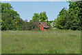
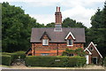
Steers Field, Denbies Hillside
A cottage beside Steers Field, part of the National Trust downland near Dorking.
Image: © Alan Hunt
Taken: 24 May 2016
0.01 miles
3
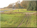
Erosion by Ranmore Common Road
Despite the adjacent minor road, ruts caused by wheeled traffic disfigure the chalk grassland.
Image: © Colin Smith
Taken: 23 Nov 2011
0.04 miles
4
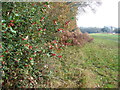
Ranmore Common Road
Woodland edge along the ridgeline of the North Downs with holly berries and bracken adding colour.
Image: © Colin Smith
Taken: 23 Nov 2011
0.04 miles
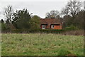
5
Fox Cottages, Ranmore Common Road, Surrey
An attractive pair of cottages in a rural location.
Image: © Peter Trimming
Taken: 10 Jul 2009
0.07 miles
6
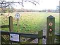
Steer's Field
Entering a patch of chalk grassland on top of the North Downs at Ranmore. Despite the sign, no cattle (Belted Galloway) were seen grazing - they are used to prevent trees and shrubs regenerating.
Image: © Colin Smith
Taken: 23 Nov 2011
0.07 miles
7
Ranmore Common Road: the pond
View east along the ride on the south side of Ranmore Common Road, towards the pond in the dip near Fox Lane.
Image: © Hugh Craddock
Taken: 7 Sep 2009
0.07 miles
8
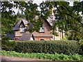
Cottage on Ranmore Common Road
This is one of the Fox Cottages.
Image: © Shazz
Taken: 30 Oct 2010
0.07 miles
9

Ranmore Common Road: towards Rose Cottage
The ride along the south side of Ranmore Common Road, dropping down to the pond, with Rose Cottage visible on the other side of the road. Out of sight, beyond the pond and tree, is Denbies Hillside National Trust car park.
Image: © Hugh Craddock
Taken: 7 Sep 2009
0.07 miles
10

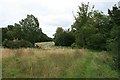
Denbies Hillside
Chalk grassland on top of the North Downs ridge at Ranmore. The hillside takes its name from a John Denby who was known to be a farmer here in the 1600s. Mist fills the valley below in the distance by Westcott.
Image: © Colin Smith
Taken: 23 Nov 2011
0.07 miles