IMAGES TAKEN NEAR TO
Guildford Road, DORKING, RH5 6SH
Introduction
This page details the photographs taken nearby to Guildford Road, RH5 6SH by members of the Geograph project.
The Geograph project started in 2005 with the aim of publishing, organising and preserving representative images for every square kilometre of Great Britain, Ireland and the Isle of Man.

There are currently over 7.5m images from over14,400 individuals and you can help contribute to the project by visiting https://www.geograph.org.uk
Image Map
Images are licensed for reuse under creativecommons.org/licenses/by-sa/2.0
Notes
- Clicking on the map will re-center to the selected point.
- The higher the marker number, the further away the image location is from the centre of the postcode.
Image Listing (23 Images Found)
Images are licensed for reuse under creativecommons.org/licenses/by-sa/2.0
Image
Details
Distance
2
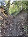
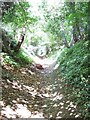
Holloway on bridleway Abinger 10
Deeply incised holloway on bridleway Abinger 10, ascending from Paddington Farm crossroads to Broomy Downs.
Image: © Hugh Craddock
Taken: 3 Mar 2024
0.04 miles
3
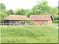
Paddington Mill
Former mill on the Tilling Bourne, east of Abinger Hammer. It is now residential.
Image: © Colin Smith
Taken: 24 May 2008
0.09 miles
4
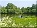
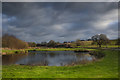
Abinger Hammer - Angling
Pond at Paddington Farm in the Tillingbourne Valley.
Image: © Colin Smith
Taken: 27 May 2016
0.09 miles
5
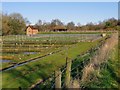
Fish-farm west of Paddington Mill
Fish ponds in the flood-plain of the Tilling Bourne.
The red brick building on the far side of the ponds is Paddington Mill, now converted for residential purposes.
Image: © Stefan Czapski
Taken: 26 Mar 2012
0.09 miles
7
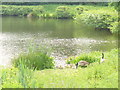
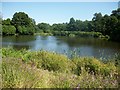
Paddington Millpond
This pond is in the Tilling Bourne valley. A family of geese is sitting on the bank. The old mill (behind camera) is now residential accommodation.
Image: © Colin Smith
Taken: 24 May 2008
0.13 miles
8
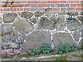
Galetted stonework, Paddington Farm
Here the mortar courses have been decorated with what may be iron-stone. This is the lower part of the wall of an old threshing barn. Compare Image, in an adjacent grid-square - the materials used are strikingly similar.
Image: © Stefan Czapski
Taken: 26 Mar 2012
0.17 miles
9
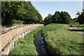
Wall beside the Tillingbourne
The Tillingbourne flows for 24 kms through some of Surrey's most picturesque villages. It is a tributary of the River Wey which it joins near Guildford.
https://en.wikipedia.org/wiki/River_Tillingbourne
Image: © Des Blenkinsopp
Taken: 5 Sep 2023
0.17 miles