IMAGES TAKEN NEAR TO
Rad Lane, DORKING, RH5 6RA
Introduction
This page details the photographs taken nearby to Rad Lane, RH5 6RA by members of the Geograph project.
The Geograph project started in 2005 with the aim of publishing, organising and preserving representative images for every square kilometre of Great Britain, Ireland and the Isle of Man.

There are currently over 7.5m images from over14,400 individuals and you can help contribute to the project by visiting https://www.geograph.org.uk
Image Map
Images are licensed for reuse under creativecommons.org/licenses/by-sa/2.0
Notes
- Clicking on the map will re-center to the selected point.
- The higher the marker number, the further away the image location is from the centre of the postcode.
Image Listing (3 Images Found)
Images are licensed for reuse under creativecommons.org/licenses/by-sa/2.0
Image
Details
Distance
1
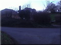
House on the corner of Rad Lane, Abinger Hammer
Since Google filmed this road the house now has two dormer roof windows and a new outbuilding which must have been added around 2011.
Image: © David Howard
Taken: 22 Jan 2012
0.12 miles
3
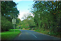
B2126 Horsham Road
"On-coming buses in middle of road for 1 1/4 miles" but I didn't meet a single one!
Image: © Robin Webster
Taken: 18 Oct 2011
0.17 miles