IMAGES TAKEN NEAR TO
West Lane, DORKING, RH5 6QS
Introduction
This page details the photographs taken nearby to West Lane, RH5 6QS by members of the Geograph project.
The Geograph project started in 2005 with the aim of publishing, organising and preserving representative images for every square kilometre of Great Britain, Ireland and the Isle of Man.

There are currently over 7.5m images from over14,400 individuals and you can help contribute to the project by visiting https://www.geograph.org.uk
Image Map
Images are licensed for reuse under creativecommons.org/licenses/by-sa/2.0
Notes
- Clicking on the map will re-center to the selected point.
- The higher the marker number, the further away the image location is from the centre of the postcode.
Image Listing (9 Images Found)
Images are licensed for reuse under creativecommons.org/licenses/by-sa/2.0
Image
Details
Distance
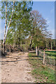
1
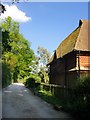
Track by Deerleap Wood
The tile-hung cottage (most likely a Wotton Estate cottage) is known as Deerleap. A little further east the track meets West Lane, which is a made-up road.
Image: © Stefan Czapski
Taken: 25 May 2017
0.01 miles
3
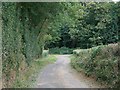
West Lane
West Lane, on the North side of the Guildford Road, leading to Image and Deerleap Wood.
Image: © Hugh Craddock
Taken: 7 Sep 2009
0.08 miles
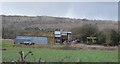
4
Track
Track leading from Park Farm to White Down Lane, alongside Deerleap Wood.
Image: © Ian Capper
Taken: 21 Apr 2022
0.19 miles
7
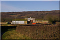
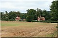
Westlane Barn
A large barn complex next to West Lane, off the A25.
In the background on the North Downs, above the electricity pole, can be seen a WW2 pillbox.
Image: © Ian Capper
Taken: 12 Jan 2008
0.21 miles
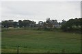
8
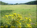
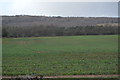
Grassland by Deerleap Wood
Looking east, over ragwort, to Park Farm in the distance.
Image: © Colin Smith
Taken: 27 Aug 2007
0.23 miles