IMAGES TAKEN NEAR TO
The Dene, DORKING, RH5 6PX
Introduction
This page details the photographs taken nearby to The Dene, RH5 6PX by members of the Geograph project.
The Geograph project started in 2005 with the aim of publishing, organising and preserving representative images for every square kilometre of Great Britain, Ireland and the Isle of Man.

There are currently over 7.5m images from over14,400 individuals and you can help contribute to the project by visiting https://www.geograph.org.uk
Image Map
Images are licensed for reuse under creativecommons.org/licenses/by-sa/2.0
Notes
- Clicking on the map will re-center to the selected point.
- The higher the marker number, the further away the image location is from the centre of the postcode.
Image Listing (5 Images Found)
Images are licensed for reuse under creativecommons.org/licenses/by-sa/2.0
Image
Details
Distance
1
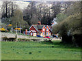
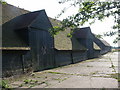
Surrey Hills: Nos. 1 and 2, The Dene
Off Raikes Lane
Image: © Dr Neil Clifton
Taken: 19 Apr 2015
0.04 miles
2
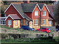
Surrey Hills: Nos. 1 and 2, The Dene
From the same place as the previous picture, but making greater use of the zoom facility.
Image: © Dr Neil Clifton
Taken: 19 Apr 2015
0.05 miles
3
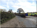
Surrey Hills: Earthworks off Raikes Lane
Image: © Dr Neil Clifton
Taken: 19 Apr 2015
0.17 miles
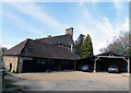
5
Crossways Farm
Part of Crossways Farm, just south of the A25 neat Abinger Hammer.
Image: © Ben Gamble
Taken: 16 Jul 2005
0.24 miles