IMAGES TAKEN NEAR TO
Raikes Hollow, DORKING, RH5 6PU
Introduction
This page details the photographs taken nearby to Raikes Hollow, RH5 6PU by members of the Geograph project.
The Geograph project started in 2005 with the aim of publishing, organising and preserving representative images for every square kilometre of Great Britain, Ireland and the Isle of Man.

There are currently over 7.5m images from over14,400 individuals and you can help contribute to the project by visiting https://www.geograph.org.uk
Image Map (Loading...)


Getting Data...Please wait
Leaflet Map data © OpenStreetMap
Images are licensed for reuse under creativecommons.org/licenses/by-sa/2.0
Notes
- Clicking on the map will re-center to the selected point.
- The higher the marker number, the further away the image location is from the centre of the postcode.
Image Listing (48 Images Found)
Images are licensed for reuse under creativecommons.org/licenses/by-sa/2.0
Image
Details
Distance
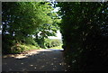
1
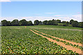
Near Sutton Abinger
Footpath through the field near Sutton Abinger.
Image: © Wayland Smith
Taken: 18 Jul 2020
0.07 miles
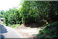
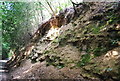
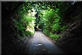
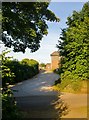
3
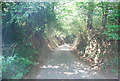
Raikes Hollow
Raikes Lane forms a sunken lane as it descends Raikes Hollow.
Image: © N Chadwick
Taken: 3 Jul 2011
0.09 miles
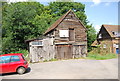
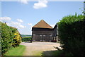
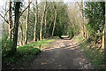
9
The entrance to Raikes Farm
Apparently part of the Wotton Estate.
Image: © Stefan Czapski
Taken: 25 Jun 2015
0.12 miles