IMAGES TAKEN NEAR TO
Holmbury St. Mary, DORKING, RH5 6NL
Introduction
This page details the photographs taken nearby to RH5 6NL by members of the Geograph project.
The Geograph project started in 2005 with the aim of publishing, organising and preserving representative images for every square kilometre of Great Britain, Ireland and the Isle of Man.

There are currently over 7.5m images from over14,400 individuals and you can help contribute to the project by visiting https://www.geograph.org.uk
Image Map
Images are licensed for reuse under creativecommons.org/licenses/by-sa/2.0
Notes
- Clicking on the map will re-center to the selected point.
- The higher the marker number, the further away the image location is from the centre of the postcode.
Image Listing (26 Images Found)
Images are licensed for reuse under creativecommons.org/licenses/by-sa/2.0
Image
Details
Distance
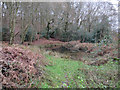
4
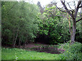
Pond on the edge of the Hurtwood, Holmbury St Mary
Pond located near the Hurtwood car park on Horsham Road, Holmbury St Mary.
Image: © Tansy Forrest-Takano
Taken: 9 May 2009
0.08 miles
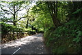
5
Small pond by the car park
On the edge of Hurt Wood, Holmbury Hill.
Image: © Hugh Venables
Taken: 26 Dec 2015
0.10 miles
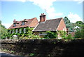
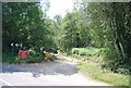
8
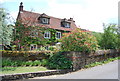
Cottage on Horsham Road, Sutton Abinger
Image: © David Howard
Taken: 1 Apr 2013
0.15 miles
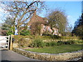
10
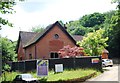
Felbury House
In the process of conversion to a luxury retirement home consisting of a mixture of self contained apartments and spacious suites. All set within a secure care setting.
Image: © N Chadwick
Taken: 3 Jul 2011
0.15 miles