IMAGES TAKEN NEAR TO
Holmbury St. Mary, DORKING, RH5 6NH
Introduction
This page details the photographs taken nearby to RH5 6NH by members of the Geograph project.
The Geograph project started in 2005 with the aim of publishing, organising and preserving representative images for every square kilometre of Great Britain, Ireland and the Isle of Man.

There are currently over 7.5m images from over14,400 individuals and you can help contribute to the project by visiting https://www.geograph.org.uk
Image Map
Images are licensed for reuse under creativecommons.org/licenses/by-sa/2.0
Notes
- Clicking on the map will re-center to the selected point.
- The higher the marker number, the further away the image location is from the centre of the postcode.
Image Listing (99 Images Found)
Images are licensed for reuse under creativecommons.org/licenses/by-sa/2.0
Image
Details
Distance
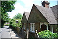
1
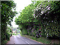
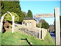
Floral approach to Holmbury St Mary
Rhododendrons alongside Horsham Road.
Image: © Tansy Forrest-Takano
Taken: 25 May 2009
0.02 miles
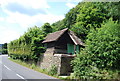
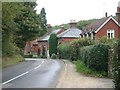
8
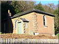
Felday Chapel
Brick chapel on the Horsham Road. A Congregational Chapel from the 19th century, it is no longer used for services.
Image: © Colin Smith
Taken: 26 Dec 2008
0.05 miles
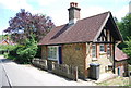
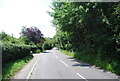
9
Felday Chapel, Holmbury St Mary
19th Century Congregational Chapel with burial ground. The Horsham Road from Abinger Hammer is on the right.
Image: © Colin Smith
Taken: 26 Dec 2008
0.05 miles
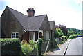
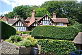
10
Houses to the east of Horsham Road, Holmbury St Mary
looking north
Image: © Andrew Longton
Taken: 28 Sep 2005
0.05 miles