IMAGES TAKEN NEAR TO
Holmbury Lane, DORKING, RH5 6NE
Introduction
This page details the photographs taken nearby to Holmbury Lane, RH5 6NE by members of the Geograph project.
The Geograph project started in 2005 with the aim of publishing, organising and preserving representative images for every square kilometre of Great Britain, Ireland and the Isle of Man.

There are currently over 7.5m images from over14,400 individuals and you can help contribute to the project by visiting https://www.geograph.org.uk
Image Map
Images are licensed for reuse under creativecommons.org/licenses/by-sa/2.0
Notes
- Clicking on the map will re-center to the selected point.
- The higher the marker number, the further away the image location is from the centre of the postcode.
Image Listing (17 Images Found)
Images are licensed for reuse under creativecommons.org/licenses/by-sa/2.0
Image
Details
Distance
1
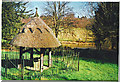
Holmbury St Mary, old village well
Thatched roof over site of old village well.
Image: © Colin Smith
Taken: Unknown
0.07 miles
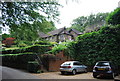
2
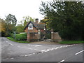
Iron gates
Impressive gates by this lodge at Holmbury St Mary.
Image: © don cload
Taken: 2 Nov 2010
0.08 miles
4
The King's Head, Holmbury St Mary
Image: © Tansy Forrest-Takano
Taken: 25 May 2009
0.15 miles
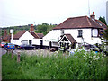
8
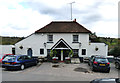
Holmbury St. Mary: The 'King's Head'
This pub lies just up a lane from the Horsham Road (B2126).
Image: © Dr Neil Clifton
Taken: 21 Oct 2014
0.18 miles