IMAGES TAKEN NEAR TO
Pasturewood Road, DORKING, RH5 6LL
Introduction
This page details the photographs taken nearby to Pasturewood Road, RH5 6LL by members of the Geograph project.
The Geograph project started in 2005 with the aim of publishing, organising and preserving representative images for every square kilometre of Great Britain, Ireland and the Isle of Man.

There are currently over 7.5m images from over14,400 individuals and you can help contribute to the project by visiting https://www.geograph.org.uk
Image Map
Images are licensed for reuse under creativecommons.org/licenses/by-sa/2.0
Notes
- Clicking on the map will re-center to the selected point.
- The higher the marker number, the further away the image location is from the centre of the postcode.
Image Listing (65 Images Found)
Images are licensed for reuse under creativecommons.org/licenses/by-sa/2.0
Image
Details
Distance
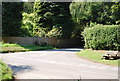
3
Junction of Abinger Common Rd and Leith Hill Rd
Image: © N Chadwick
Taken: 3 Jul 2011
0.06 miles
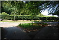
9
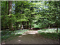
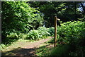
Footpath through Pasture Wood, near Abinger Common
It's the start of May and the bluebells are beginning to fade.
Image: © Tansy Forrest-Takano
Taken: 3 May 2009
0.12 miles
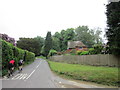
10
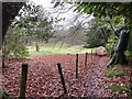
Footpath 27 at Parkhurst Wood
Footpath Abinger 27 provides a short-cut between Pasture Wood Road and Leith Hill Road.
Image: © Hugh Craddock
Taken: 31 Dec 2024
0.13 miles