IMAGES TAKEN NEAR TO
Donkey Lane, DORKING, RH5 6HY
Introduction
This page details the photographs taken nearby to Donkey Lane, RH5 6HY by members of the Geograph project.
The Geograph project started in 2005 with the aim of publishing, organising and preserving representative images for every square kilometre of Great Britain, Ireland and the Isle of Man.

There are currently over 7.5m images from over14,400 individuals and you can help contribute to the project by visiting https://www.geograph.org.uk
Image Map
Images are licensed for reuse under creativecommons.org/licenses/by-sa/2.0
Notes
- Clicking on the map will re-center to the selected point.
- The higher the marker number, the further away the image location is from the centre of the postcode.
Image Listing (119 Images Found)
Images are licensed for reuse under creativecommons.org/licenses/by-sa/2.0
Image
Details
Distance
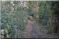
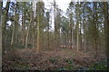
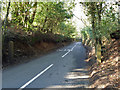
3
Leaving Abinger Bottom
The start of the footpath from Abinger Bottom, through High Copse, to Wotton.
Image: © Colin Smith
Taken: 24 May 2008
0.13 miles
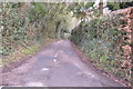
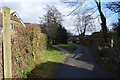
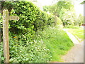
5
Manor Gate, Hollow Lane
The two fairly modern wooden posts, which never hung a gate themselves, are inscribed with "Manor Gate". A strange location for a gate on a public road, not at any parish boundary, which here runs along the right side of the lane, not across it. The nearest manor is Abinger Manor.
Image: © Robin Webster
Taken: 4 Mar 2011
0.14 miles
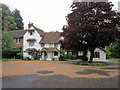
6
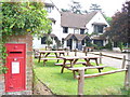
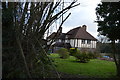
The Abinger Hatch
Popular village pub, with large beer garden, in the Surrey Hills.
Image: © Colin Smith
Taken: 24 May 2008
0.14 miles