IMAGES TAKEN NEAR TO
Coldharbour, DORKING, RH5 6HQ
Introduction
This page details the photographs taken nearby to RH5 6HQ by members of the Geograph project.
The Geograph project started in 2005 with the aim of publishing, organising and preserving representative images for every square kilometre of Great Britain, Ireland and the Isle of Man.

There are currently over 7.5m images from over14,400 individuals and you can help contribute to the project by visiting https://www.geograph.org.uk
Image Map
Images are licensed for reuse under creativecommons.org/licenses/by-sa/2.0
Notes
- Clicking on the map will re-center to the selected point.
- The higher the marker number, the further away the image location is from the centre of the postcode.
Image Listing (15 Images Found)
Images are licensed for reuse under creativecommons.org/licenses/by-sa/2.0
Image
Details
Distance
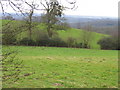
1
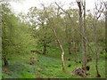
Woodland and meadows near Kitlands Farm
Image: © Diane Sambrook
Taken: 27 Apr 2008
0.15 miles
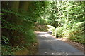
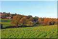
2
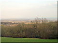
Fields beside Anstie Lane looking south
This is a lovely area with rolling hills and distant views
Image: © Pip Rolls
Taken: 17 Jan 2006
0.17 miles
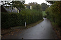
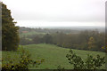
3
Near Antsie Lane, Holmwood
Isolated houses, near Holmwood in the Surrey commuter belt.
Image: © Wayland Smith
Taken: 15 Nov 2014
0.17 miles
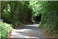
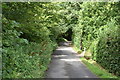
7

Anstie Lane, Coldharbour, Surrey
Dense foliage, on either side of the lane, gives the impression that you are travelling through a corridor.
Image: © Peter Trimming
Taken: 16 Jul 2009
0.21 miles