IMAGES TAKEN NEAR TO
London Road, DORKING, RH5 6EH
Introduction
This page details the photographs taken nearby to London Road, RH5 6EH by members of the Geograph project.
The Geograph project started in 2005 with the aim of publishing, organising and preserving representative images for every square kilometre of Great Britain, Ireland and the Isle of Man.

There are currently over 7.5m images from over14,400 individuals and you can help contribute to the project by visiting https://www.geograph.org.uk
Image Map
Images are licensed for reuse under creativecommons.org/licenses/by-sa/2.0
Notes
- Clicking on the map will re-center to the selected point.
- The higher the marker number, the further away the image location is from the centre of the postcode.
Image Listing (185 Images Found)
Images are licensed for reuse under creativecommons.org/licenses/by-sa/2.0
Image
Details
Distance
1
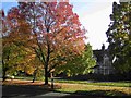
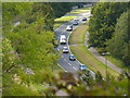
Mickleham Bends A24 Autumn 2006
This is looking across the dual carriageway of the A24 showing one of the appealing houses in Mickleham village.
Image: © Denis Loretto
Taken: Unknown
0.03 miles
2
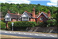
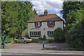
Dalewood Cottage/Abbots Cottage
On the A24 in the north part of Mickleham village. A building date of 1890 is shown on the front.
Image: © Ian Capper
Taken: 5 Jul 2010
0.03 miles
3
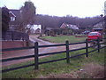
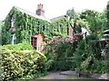
School Lane Mickleham
Box Hill is in the background
Image: © David Howard
Taken: 8 Feb 2010
0.04 miles
4
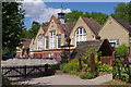
St Michael's School, Mickleham
A Church of England First School on this site since 1907.
Image: © Ian Capper
Taken: 5 Jul 2010
0.06 miles
5
Mickleham Bend
Dualled road in the Mole Gap through the North Downs.
Image: © Colin Smith
Taken: 18 Sep 2015
0.07 miles
6
St Michael's
A former restaurant on the A24 London Road.
Image: © Ian Capper
Taken: 5 Jul 2010
0.07 miles
7
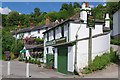
King William IV
Nice pub hidden away up a steep hill from the A24
Image: © Martyn Davies
Taken: 8 Jul 2006
0.08 miles
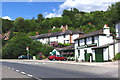
8
London Road, Mickleham
Frascati is a long established Italian restaurant. Beyond are Elm Cottages, a grade II listed terrace dating from the early 19th century. For listing particulars see www.historicengland.org.uk/listing/the-list/list-entry/1028882.
Image: © Ian Capper
Taken: 5 Jul 2010
0.08 miles
9
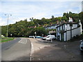
Dorking Road
At junction with Byttom Hill. Frascati Restaurant to right.
Image: © Oast House Archive
Taken: 6 Oct 2010
0.08 miles
10
London Road, Mickleham
Frascati is a long established Italian restaurant. Beyond are Elm Cottages, a grade II listed terrace dating from the early 19th century. For listing particulars see www.historicengland.org.uk/listing/the-list/list-entry/1028882.
Image: © Ian Capper
Taken: 5 Jul 2010
0.09 miles