IMAGES TAKEN NEAR TO
Crabtree Lane, DORKING, RH5 6BG
Introduction
This page details the photographs taken nearby to Crabtree Lane, RH5 6BG by members of the Geograph project.
The Geograph project started in 2005 with the aim of publishing, organising and preserving representative images for every square kilometre of Great Britain, Ireland and the Isle of Man.

There are currently over 7.5m images from over14,400 individuals and you can help contribute to the project by visiting https://www.geograph.org.uk
Image Map
Images are licensed for reuse under creativecommons.org/licenses/by-sa/2.0
Notes
- Clicking on the map will re-center to the selected point.
- The higher the marker number, the further away the image location is from the centre of the postcode.
Image Listing (86 Images Found)
Images are licensed for reuse under creativecommons.org/licenses/by-sa/2.0
Image
Details
Distance
1
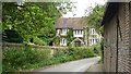
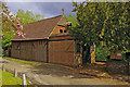
House in Crabtree Lane
A lovely old house in a quiet location. I particularly like the style of the windows.
Image: © Peter Trimming
Taken: 1 Aug 2008
0.01 miles
2
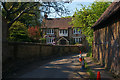
Picturesque cottage, Westhumble, Surrey
Pity about the traffic cones!
Image: © Jim Osley
Taken: 22 Apr 2011
0.02 miles
3
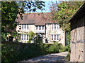
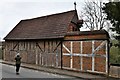
Crabtree Lane
Attractive cottage and a brick barn with timbering line this lane in Westhumble.
Image: © Colin Smith
Taken: 20 Sep 2008
0.02 miles
4
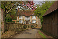
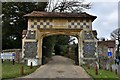
Camilla Lacey Lodge
Grade II listed cottage on Crabtree Lane dating from the early 19th century. For listing particulars see www.historicengland.org.uk/listing/the-list/list-entry/1028889. On the right is the wall of Westhumble Chapel of Ease (see Image).
Image: © Ian Capper
Taken: 3 May 2010
0.03 miles
5
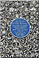
Westhumble: Fanny Burney blue plaque on the Leladene entrance
Image: © Michael Garlick
Taken: 31 Mar 2019
0.03 miles
7
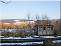
Platelayer's hut, north of Box Hill & Westhumble station
At least, that's what we'd have called it back in the days of Hornby Dublo.
By the time I took this shot, the sun had sunk below the ridge behind me, so that the foreground is in shade while the snow-dappled hills are still catching weak sunlight. The Box Hill scarp is out of shot to the right, as seen in: Image
This platelayer's hut stands close to the Dorking-Leatherhead line, which links to both Victoria and Waterloo. A few years ago, before the property bubble burst, a lock-up garage in SW London was advertised at an asking price in excess of £110,000. You can't help wondering . . .
Image: © Stefan Czapski
Taken: 7 Feb 2012
0.03 miles
8
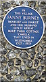
Blue Plaque at the Entrance to Camilla Drive
The plaque says it all, but I love the texture of the knapped flint wall.
Image: © Peter Trimming
Taken: 1 Aug 2008
0.03 miles
10
Chapel of Ease, Westhumble
Chapel of Ease to St Michael's Church, Mickleham, converted from a former outbuilding. Grade II listed - for listing particulars see www.historicengland.org.uk/listing/the-list/list-entry/1028888.
Image: © Ian Capper
Taken: 3 May 2010
0.04 miles