IMAGES TAKEN NEAR TO
Ranmore Common Road, DORKING, RH5 6AZ
Introduction
This page details the photographs taken nearby to Ranmore Common Road, RH5 6AZ by members of the Geograph project.
The Geograph project started in 2005 with the aim of publishing, organising and preserving representative images for every square kilometre of Great Britain, Ireland and the Isle of Man.

There are currently over 7.5m images from over14,400 individuals and you can help contribute to the project by visiting https://www.geograph.org.uk
Image Map
Images are licensed for reuse under creativecommons.org/licenses/by-sa/2.0
Notes
- Clicking on the map will re-center to the selected point.
- The higher the marker number, the further away the image location is from the centre of the postcode.
Image Listing (24 Images Found)
Images are licensed for reuse under creativecommons.org/licenses/by-sa/2.0
Image
Details
Distance
1

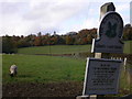
My Favourite Surrey Road
Well, there were several which I preferred to cycle up, but Ranmore Common Road was the only one where I won money for doing so.
In October 2000, the course was in use as a hill climb; this being the start and the finish being the flat stretch, after the hairpin, near the top. My prize was £20, for the fastest time by a veteran (40+).
Image: © Peter Trimming
Taken: 27 Jul 2016
0.03 miles
2
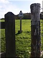
National Trust sign (second today)
A similar picture taken three years earlier is here http://www.geograph.org.uk/photo/285744. At that time the notice propped against the post was on the ground.
Image: © Shazz
Taken: 30 Oct 2010
0.04 miles
3
Footpath to the North Downs, Ranmore Common
Image: © David Howard
Taken: 16 Jan 2012
0.04 miles
4

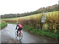
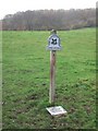
Advance Warning
Public footpath sign beside Ranmore Common Road. The yellow sign advises that the 'Ride London' cycle event would pass this location.
Image: © Peter Trimming
Taken: 27 Jul 2016
0.04 miles
5
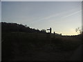
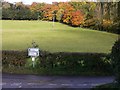
Chapel Lane, Westhumble
The tree line is Chapel Wood
Image: © Martyn Davies
Taken: 26 Nov 2006
0.04 miles
6
Third National Trust sign today
This sign is at the junction of Ranmore Common Road with Chapel Lane.
Image: © Shazz
Taken: 30 Oct 2010
0.05 miles
7
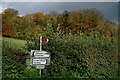
Road junction near Westhumble
This is where Ranmore Common Road meets Chapel Lane.
Image: © Shazz
Taken: 30 Oct 2010
0.06 miles
8
Westhumble
The junction of Chapel Lane with Ranmore Common Road.
Image: © Peter Trimming
Taken: 7 Nov 2023
0.06 miles
9

Chapel Farm Fields
National Trust land, to the west of Westhumble.
Image: © Peter Trimming
Taken: 27 Jul 2016
0.06 miles
10
Chapel Farm Fields
National trust land. The footpath here leads to Westhumble village or Denbies vineyard.
Image: © Martyn Davies
Taken: 26 Nov 2006
0.07 miles