IMAGES TAKEN NEAR TO
Adlers Lane, DORKING, RH5 6AS
Introduction
This page details the photographs taken nearby to Adlers Lane, RH5 6AS by members of the Geograph project.
The Geograph project started in 2005 with the aim of publishing, organising and preserving representative images for every square kilometre of Great Britain, Ireland and the Isle of Man.

There are currently over 7.5m images from over14,400 individuals and you can help contribute to the project by visiting https://www.geograph.org.uk
Image Map
Images are licensed for reuse under creativecommons.org/licenses/by-sa/2.0
Notes
- Clicking on the map will re-center to the selected point.
- The higher the marker number, the further away the image location is from the centre of the postcode.
Image Listing (70 Images Found)
Images are licensed for reuse under creativecommons.org/licenses/by-sa/2.0
Image
Details
Distance
1

Adlers Lane, Westhumble, near Dorking
Adlers Lane in the village of Westhumble, in the North Downs.
Image: © Malc McDonald
Taken: 28 Jul 2019
0.03 miles
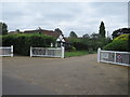
2
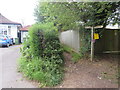
Public footpath, Westhumble, near Dorking
The wooden sign indicates the route of a public footpath in the village of Westhumble, in Surrey.
Image: © Malc McDonald
Taken: 28 Jul 2019
0.03 miles
3
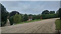
Westhumble - Pilgrims Way
Private road housing estate.
Image: © James Emmans
Taken: 14 Aug 2021
0.08 miles
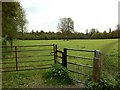
4
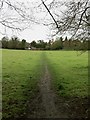
Footpath to Adlers Lane
Footpath across the field between the Denbies carriage drive and the end of Adlers Lane. The footpath is not recorded on the definitive map, but is well used, and fitted with pedestrian gates at both end.
Image: © Hugh Craddock
Taken: 5 May 2012
0.11 miles
5
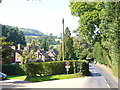
Chapel Lane, Westhumble
Rural lane leading from the hamlet centre to the ruined chapel.
Image: © Colin Smith
Taken: 20 Sep 2008
0.11 miles
6
Pilgrims Way, Westhumble, near Dorking
Pilgrims Way is a private residential road in the village of Westhumble, in Surrey.
Image: © Malc McDonald
Taken: 28 Jul 2019
0.12 miles
7
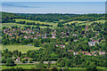
Westhumble
The village of Westhumble, seen from Burford Spur on Box Hill.
Image: © Ian Capper
Taken: 9 Jun 2021
0.14 miles
8
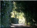
Chapel Lane, Westhumble
The lane leads up the dry valley towards Ranmore and Polesden Lacey.
Image: © Thomas Grant
Taken: Unknown
0.15 miles
9
End of Adlers Lane
Eastern end of the motorable section of Adlers Lane, which terminates at a gate into what is shown on the map as 'Gravel Pit Plantation' (the western end of the field was planted with trees until after the IIWW). Adlers Lane used to continue along the hedge line on the left over the railway to the main road. The pedestrian gate on the right permits access across the field to the Denbies carriage drive (the footpath is not recorded on the definitive map, but appears on Ordnance Survey maps).
Image: © Hugh Craddock
Taken: 5 May 2012
0.16 miles
10
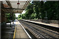
Towards Dorking
Southern railway at Box Hill and Westhumble station, looking south.
Image: © Paul E Smith
Taken: 17 May 2009
0.16 miles