IMAGES TAKEN NEAR TO
Guildford Road, DORKING, RH5 6AG
Introduction
This page details the photographs taken nearby to Guildford Road, RH5 6AG by members of the Geograph project.
The Geograph project started in 2005 with the aim of publishing, organising and preserving representative images for every square kilometre of Great Britain, Ireland and the Isle of Man.

There are currently over 7.5m images from over14,400 individuals and you can help contribute to the project by visiting https://www.geograph.org.uk
Image Map
Images are licensed for reuse under creativecommons.org/licenses/by-sa/2.0
Notes
- Clicking on the map will re-center to the selected point.
- The higher the marker number, the further away the image location is from the centre of the postcode.
Image Listing (60 Images Found)
Images are licensed for reuse under creativecommons.org/licenses/by-sa/2.0
Image
Details
Distance
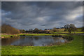
2
Pond at Kingfisher Farm, Abinger Hammer
Image: © David Howard
Taken: 15 Sep 2008
0.03 miles
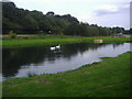
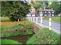
3
Wall beside the Tillingbourne
The Tillingbourne flows for 24 kms through some of Surrey's most picturesque villages. It is a tributary of the River Wey which it joins near Guildford.
https://en.wikipedia.org/wiki/River_Tillingbourne
Image: © Des Blenkinsopp
Taken: 5 Sep 2023
0.04 miles
4
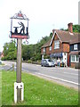
Abinger Hammer Village Sign
Showing a blacksmith at work in this village which has a medieval iron-working history. A modern blacksmith / farrier now has a forge just right, off photograph. The village shop is behind the parked car.
Image: © Colin Smith
Taken: 24 May 2008
0.04 miles
5
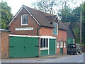
Abinger Hammer Motors
Long established commercial concern sited near the T-junction in Abinger Hammer village.
Image: © Colin Smith
Taken: 10 Jul 2011
0.05 miles
7
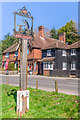
Abinger Hammer village sign
Village sign for Abinger Hammer, depicting a blacksmith and his anvil. Note also the cyclist motifs on the base. In the background are the village shop and part of Grasmere (see Image and Image).
Image: © Ian Capper
Taken: 4 Apr 2023
0.06 miles
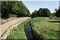
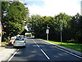
8
Bridge on Felday Road
On the B2126, approaching Abinger Hammer from the south. The bridge crosses the Tilling Bourne. In the distance are the village post office / shop and a weatherboarded cottage.
Image: © Colin Smith
Taken: 7 Oct 2007
0.07 miles
10
Abinger Hammer Tea Rooms
On the A25 opposite the B2126 Felday Road junction.
Image: © Robin Webster
Taken: 21 Sep 2011
0.07 miles