IMAGES TAKEN NEAR TO
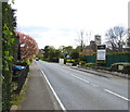
Stane Street, DORKING, RH5 5TG
Introduction
This page details the photographs taken nearby to Stane Street, RH5 5TG by members of the Geograph project.
The Geograph project started in 2005 with the aim of publishing, organising and preserving representative images for every square kilometre of Great Britain, Ireland and the Isle of Man.

There are currently over 7.5m images from over14,400 individuals and you can help contribute to the project by visiting https://www.geograph.org.uk
Image Map
Images are licensed for reuse under creativecommons.org/licenses/by-sa/2.0
Notes
- Clicking on the map will re-center to the selected point.
- The higher the marker number, the further away the image location is from the centre of the postcode.
Image Listing (49 Images Found)
Images are licensed for reuse under creativecommons.org/licenses/by-sa/2.0
Image
Details
Distance
1
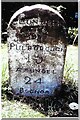
Old Milestone, A29, Stane Street, by Milestone Cottage
The milestone is located 50m South of the Cricketers Arms public house, on the North West side of the road on the cut verge between pavement and house. Parish of Ockley (Mole Valley District). Carved stone post, Ockley stone design, erected by Ockley & Warnham turnpike trust in the 19th century.
Inscription reads:- LONDON / 31 / PULBOROUGH / 15 / ARUNDEL / 24 / BOGNOR / 31
Grade II listed by Historic England, List Entry Number: 1028710 https://historicengland.org.uk/listing/the-list/list-entry/1028710
Milestone Society National ID: SY_LAA31
Image: © Janet Dowding
Taken: Unknown
0.03 miles
2
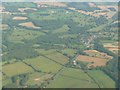
Surrey : Mole Valley - Okley from the Air
Looking down to the countryside near Okley from an inbound flight to Gatwick.
Image: © Lewis Clarke
Taken: 1 Sep 2011
0.04 miles
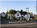
6
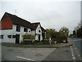
The Cricketers Arms public house, Ockley
Image: © Stacey Harris
Taken: 4 May 2012
0.07 miles
7
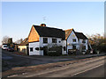
The Cricketers Arms
Not marked as a public house on the 1879 OS map.
Image: © Andy Potter
Taken: 9 Jan 2009
0.07 miles
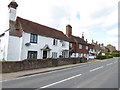
9
Development on Stane Street
Cottages are being developed on the site of the erstwhile public house which had been the old school house.
See also http://www.geograph.org.uk/photo/1221189.
Image: © Shazz
Taken: 15 Apr 2017
0.09 miles
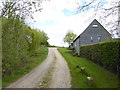
10
The Old School House
Home to the acclaimed Bryce's Fresh Seafood & Fish Restaurant http://www.bryces.co.uk/. The 1879 OS map shows the National School on the green to the north so I don't know when this was a school.
Image: © Andy Potter
Taken: 9 Jan 2009
0.10 miles