IMAGES TAKEN NEAR TO
Oakfields, DORKING, RH5 5RQ
Introduction
This page details the photographs taken nearby to Oakfields, RH5 5RQ by members of the Geograph project.
The Geograph project started in 2005 with the aim of publishing, organising and preserving representative images for every square kilometre of Great Britain, Ireland and the Isle of Man.

There are currently over 7.5m images from over14,400 individuals and you can help contribute to the project by visiting https://www.geograph.org.uk
Image Map
Images are licensed for reuse under creativecommons.org/licenses/by-sa/2.0
Notes
- Clicking on the map will re-center to the selected point.
- The higher the marker number, the further away the image location is from the centre of the postcode.
Image Listing (27 Images Found)
Images are licensed for reuse under creativecommons.org/licenses/by-sa/2.0
Image
Details
Distance
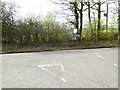
1
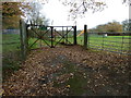
Entrance to pumping station next to Walliswood play area
Image: © Dave Spicer
Taken: 4 Dec 2011
0.05 miles
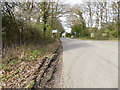
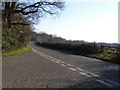
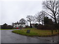
3
Road junction at the southern end of Walliswood
The road left leads to Okewood Hill.
Image: © Dave Spicer
Taken: 4 Dec 2011
0.07 miles
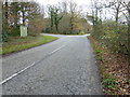
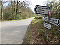
4
Horsham Road at the junction of Okewood Hill
Image: © David Howard
Taken: 1 Apr 2013
0.07 miles
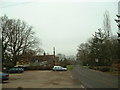
6
Looking south on Horsham Road
The junction on the left is with Oakwood Hill.
Image: © Shazz
Taken: 30 Mar 2017
0.09 miles
9
Walliswood
Looking North into the village - pub on the right is Scarlett Arms.
Image: © Chris Shaw
Taken: 4 Feb 2006
0.13 miles