IMAGES TAKEN NEAR TO
Sheep Green, DORKING, RH5 5RP
Introduction
This page details the photographs taken nearby to Sheep Green, RH5 5RP by members of the Geograph project.
The Geograph project started in 2005 with the aim of publishing, organising and preserving representative images for every square kilometre of Great Britain, Ireland and the Isle of Man.

There are currently over 7.5m images from over14,400 individuals and you can help contribute to the project by visiting https://www.geograph.org.uk
Image Map
Images are licensed for reuse under creativecommons.org/licenses/by-sa/2.0
Notes
- Clicking on the map will re-center to the selected point.
- The higher the marker number, the further away the image location is from the centre of the postcode.
Image Listing (14 Images Found)
Images are licensed for reuse under creativecommons.org/licenses/by-sa/2.0
Image
Details
Distance
1
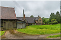
Hartshurst Farm
16th Century farmhouse. Grade II listed - see www.historicengland.org.uk/listing/the-list/list-entry/1028811.
Image: © Ian Capper
Taken: 12 May 2018
0.01 miles
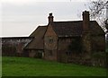
2
Hartshurst Farm
16th Century farmhouse, on the right of the photo. Grade II listed - see www.historicengland.org.uk/listing/the-list/list-entry/1028811.
The granary on the far left of the photo is from the 18th Century and is separately grade II listed - see www.historicengland.org.uk/listing/the-list/list-entry/1189957.
Image: © Ian Capper
Taken: 12 May 2018
0.01 miles
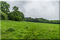
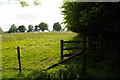
4
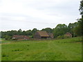
Hartshurst Farm
Collection of farm buildings amidst fields at the southern foot of Leith Hill.
Image: © Colin Smith
Taken: 15 May 2011
0.03 miles
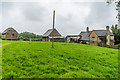
5
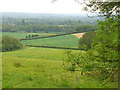
East of Hartshurst Farm
Looking east from near Hartshurst Farm.
Image: © Ian Capper
Taken: 12 May 2018
0.07 miles
6
View south-eastwards from Leith Hill Place
Image: © Christopher Hilton
Taken: 12 Sep 2010
0.13 miles
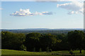
7
Sheep Green from Leith Hill
View southwards from sandy Leith Hill to the Weald below with its mix of farmland and woodland. On the skyline, about 25-30 miles away, are the South Downs.
Image: © Colin Smith
Taken: 15 May 2011
0.14 miles
8
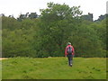
Onwards and Upwards
On the grassy path from Hartshurst Farm to wooded Leith Hill. On the skyline is Leith Hill Tower, built on Surrey's highest hill (295 metres amsl).
Image: © Colin Smith
Taken: 15 May 2011
0.14 miles
9
Footpath south of Leith Hill Place Wood
Image: © Christopher Hilton
Taken: 9 Jun 2013
0.17 miles
10
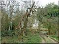
Tree 05868, Church Wood
The tree number is on a green National Trust tag fixed to the trunk. This tree, which appears to be an apple or similar, is sadly in poor shape. It is remarkable for the spirally fluted trunk. It seems very unlikely this is natural - probably several stems were trained together.
Image: © Robin Webster
Taken: 21 Mar 2011
0.21 miles