IMAGES TAKEN NEAR TO
Horsham Road, DORKING, RH5 5QD
Introduction
This page details the photographs taken nearby to Horsham Road, RH5 5QD by members of the Geograph project.
The Geograph project started in 2005 with the aim of publishing, organising and preserving representative images for every square kilometre of Great Britain, Ireland and the Isle of Man.

There are currently over 7.5m images from over14,400 individuals and you can help contribute to the project by visiting https://www.geograph.org.uk
Image Map
Images are licensed for reuse under creativecommons.org/licenses/by-sa/2.0
Notes
- Clicking on the map will re-center to the selected point.
- The higher the marker number, the further away the image location is from the centre of the postcode.
Image Listing (8 Images Found)
Images are licensed for reuse under creativecommons.org/licenses/by-sa/2.0
Image
Details
Distance
1
Entrance on Horsham Road to the Oakwood Hill estate
Image: © Shazz
Taken: 15 Apr 2017
0.14 miles
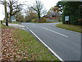
3
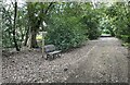
Seat on the border path
The Sussex Border Path passes the seat near Honeywood House.
Image: © Chris Thomas-Atkin
Taken: 7 May 2021
0.19 miles
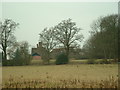
4
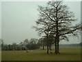
Sheepfield
Looking West from the road, near Ridge Farm
Image: © Chris Shaw
Taken: 4 Feb 2006
0.19 miles
5
Pinkhurst Farm
Viewed from the road to the NE
Image: © Chris Shaw
Taken: 4 Feb 2006
0.21 miles
6
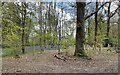
Oakwood Wood
Bluebells in Oakwood Wood beside the Sussex Border Path.
Image: © Chris Thomas-Atkin
Taken: 7 May 2021
0.22 miles
7
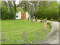
Gatehouse at entrance to Honeywood House
A nursing home.
Image: © Dave Spicer
Taken: 4 Dec 2011
0.24 miles
8
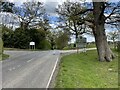
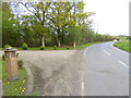
County boundary
On the Horsham Road near Honeywood House the Sussex Border Path follows the county boundary between Sussex and Surrey.
Image: © Chris Thomas-Atkin
Taken: 7 May 2021
0.24 miles