IMAGES TAKEN NEAR TO
Forest Green, DORKING, RH5 5PR
Introduction
This page details the photographs taken nearby to RH5 5PR by members of the Geograph project.
The Geograph project started in 2005 with the aim of publishing, organising and preserving representative images for every square kilometre of Great Britain, Ireland and the Isle of Man.

There are currently over 7.5m images from over14,400 individuals and you can help contribute to the project by visiting https://www.geograph.org.uk
Image Map
Images are licensed for reuse under creativecommons.org/licenses/by-sa/2.0
Notes
- Clicking on the map will re-center to the selected point.
- The higher the marker number, the further away the image location is from the centre of the postcode.
Image Listing (6 Images Found)
Images are licensed for reuse under creativecommons.org/licenses/by-sa/2.0
Image
Details
Distance
1
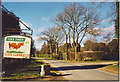
Ives Farm, Forest Green.
The country road to Forest Green from the south passes this farm sign which advertises a pedigree herd of Guernsey cows. These are prized for their milk.
Image: © Colin Smith
Taken: 8 Apr 2006
0.08 miles
2
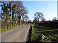
Horsham Road, Forest Green
The only explanation I can think of for the two sets of telegraph poles would be the dark ones carry electricity while the others carry the phone supply, but have never seen two sets alongside each other before.
Image: © David Howard
Taken: 1 Apr 2013
0.09 miles
3
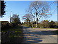
Horsham Road, Forest Green
Ives Farm is on the left, Jordan's Farm is on the right
Image: © David Howard
Taken: 1 Apr 2013
0.09 miles
4
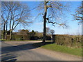
The entrance to Jordan's Farm, Forest Green
Image: © David Howard
Taken: 1 Apr 2013
0.10 miles
5
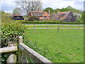
Bridgham Farm
Wealden farm with several grassy paddocks and much horsieculture.
Image: © Colin Smith
Taken: 9 May 2009
0.14 miles
6
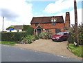
Surrey: Redhill Cottage
On the road between Forest Green and Mayes Green.
Image: © Dr Neil Clifton
Taken: 21 Oct 2014
0.24 miles