IMAGES TAKEN NEAR TO
Mayes Green, DORKING, RH5 5PN
Introduction
This page details the photographs taken nearby to Mayes Green, RH5 5PN by members of the Geograph project.
The Geograph project started in 2005 with the aim of publishing, organising and preserving representative images for every square kilometre of Great Britain, Ireland and the Isle of Man.

There are currently over 7.5m images from over14,400 individuals and you can help contribute to the project by visiting https://www.geograph.org.uk
Image Map
Images are licensed for reuse under creativecommons.org/licenses/by-sa/2.0
Notes
- Clicking on the map will re-center to the selected point.
- The higher the marker number, the further away the image location is from the centre of the postcode.
Image Listing (24 Images Found)
Images are licensed for reuse under creativecommons.org/licenses/by-sa/2.0
Image
Details
Distance
1
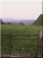
View across fields towards the Downs, from the high ground by Pond Head
Image: © Christopher Hilton
Taken: 29 Apr 2007
0.08 miles
2
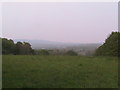
View across fields towards the Downs, from the high ground by Pond Head
Image: © Christopher Hilton
Taken: 29 Apr 2007
0.08 miles
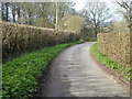
3
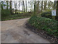
Pond Head Lane with footpath junction on right
Image: © Shazz
Taken: 30 Mar 2017
0.08 miles
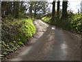
5
Pond Head Lane going north
Here the lane has public bridleway status.
Image: © Shazz
Taken: 30 Mar 2017
0.10 miles
7
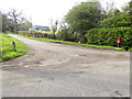
Junction of Horsham Road and Pond Head Lane
A different view is at http://www.geograph.org.uk/photo/2721752.
Image: © Shazz
Taken: 30 Mar 2017
0.11 miles
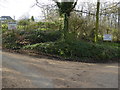
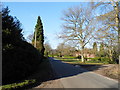
8
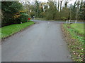
Pond Head lane meets Horsham Road at Mayes Green
Image: © Dave Spicer
Taken: 4 Dec 2011
0.12 miles
10
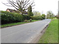
Horsham Road passes large dwelling at Mayes Green
Image: © Shazz
Taken: 30 Mar 2017
0.14 miles