IMAGES TAKEN NEAR TO
Leith Hill Lane, DORKING, RH5 5PH
Introduction
This page details the photographs taken nearby to Leith Hill Lane, RH5 5PH by members of the Geograph project.
The Geograph project started in 2005 with the aim of publishing, organising and preserving representative images for every square kilometre of Great Britain, Ireland and the Isle of Man.

There are currently over 7.5m images from over14,400 individuals and you can help contribute to the project by visiting https://www.geograph.org.uk
Image Map
Images are licensed for reuse under creativecommons.org/licenses/by-sa/2.0
Notes
- Clicking on the map will re-center to the selected point.
- The higher the marker number, the further away the image location is from the centre of the postcode.
Image Listing (8 Images Found)
Images are licensed for reuse under creativecommons.org/licenses/by-sa/2.0
Image
Details
Distance
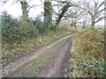
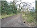
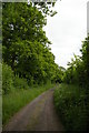
1
View south down the side of Church Wood
Image: © Christopher Hilton
Taken: 9 Jun 2013
0.07 miles
4
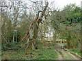
Tree 05868, Church Wood
The tree number is on a green National Trust tag fixed to the trunk. This tree, which appears to be an apple or similar, is sadly in poor shape. It is remarkable for the spirally fluted trunk. It seems very unlikely this is natural - probably several stems were trained together.
Image: © Robin Webster
Taken: 21 Mar 2011
0.15 miles
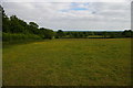
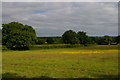
5
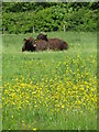
Forest Green - Etherley Farm
Buttercups and contented cows in the Wealden sunshine.
Image: © Colin Smith
Taken: 13 May 2022
0.19 miles