IMAGES TAKEN NEAR TO
Pisley Farm Road, DORKING, RH5 5PD
Introduction
This page details the photographs taken nearby to Pisley Farm Road, RH5 5PD by members of the Geograph project.
The Geograph project started in 2005 with the aim of publishing, organising and preserving representative images for every square kilometre of Great Britain, Ireland and the Isle of Man.

There are currently over 7.5m images from over14,400 individuals and you can help contribute to the project by visiting https://www.geograph.org.uk
Image Map
Images are licensed for reuse under creativecommons.org/licenses/by-sa/2.0
Notes
- Clicking on the map will re-center to the selected point.
- The higher the marker number, the further away the image location is from the centre of the postcode.
Image Listing (3 Images Found)
Images are licensed for reuse under creativecommons.org/licenses/by-sa/2.0
Image
Details
Distance
2
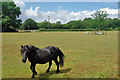
Attentive black pony
A horse and pony were in this field on Fishfold Farm, both most interested in passing walkers with bags. The horse was probably about one metre behind the viewpoint!
Image: © Robin Webster
Taken: 22 Jul 2010
0.16 miles