IMAGES TAKEN NEAR TO
Ryersh Lane, DORKING, RH5 5LJ
Introduction
This page details the photographs taken nearby to Ryersh Lane, RH5 5LJ by members of the Geograph project.
The Geograph project started in 2005 with the aim of publishing, organising and preserving representative images for every square kilometre of Great Britain, Ireland and the Isle of Man.

There are currently over 7.5m images from over14,400 individuals and you can help contribute to the project by visiting https://www.geograph.org.uk
Image Map
Images are licensed for reuse under creativecommons.org/licenses/by-sa/2.0
Notes
- Clicking on the map will re-center to the selected point.
- The higher the marker number, the further away the image location is from the centre of the postcode.
Image Listing (1 Images Found)
Images are licensed for reuse under creativecommons.org/licenses/by-sa/2.0
Image
Details
Distance
1
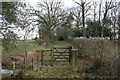
Ryersh Lane
Ryersh Lane (public bridleway Capel 157) was once a bridleroad between Beare Green and Ockley: here, it climbs from a crossing over a stream, along an old green lane, towards Ryersh Farm.
Behind the photographer is the Capel bypass. Although it is possible to cross the Capel bypass on the level, there are no facilities (such as a bridge, underpass or even refuges for horse-riders), and the experience is not a pleasant one even when traffic makes a crossing practicable. There appears no longer to be any use at all by horse riders.
Image: © Hugh Craddock
Taken: 7 Feb 2009
0.15 miles