IMAGES TAKEN NEAR TO
The Street, DORKING, RH5 5LA
Introduction
This page details the photographs taken nearby to The Street, RH5 5LA by members of the Geograph project.
The Geograph project started in 2005 with the aim of publishing, organising and preserving representative images for every square kilometre of Great Britain, Ireland and the Isle of Man.

There are currently over 7.5m images from over14,400 individuals and you can help contribute to the project by visiting https://www.geograph.org.uk
Image Map
Images are licensed for reuse under creativecommons.org/licenses/by-sa/2.0
Notes
- Clicking on the map will re-center to the selected point.
- The higher the marker number, the further away the image location is from the centre of the postcode.
Image Listing (73 Images Found)
Images are licensed for reuse under creativecommons.org/licenses/by-sa/2.0
Image
Details
Distance
1
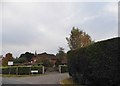
Old Barn Drive at the junction with The Street
Image: © David Howard
Taken: 23 Oct 2016
0.10 miles
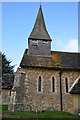
2
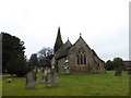
St. John the Baptist, Capel: late January 2017
Image: © Basher Eyre
Taken: 30 Jan 2017
0.10 miles
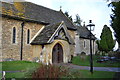
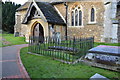
3
Church of St John the Baptist, Capel
Partly dating from the C12, but heavily restored in the C19.
Image: © Hugh Craddock
Taken: 7 Feb 2009
0.10 miles
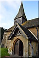
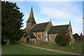
4
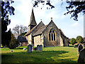
Capel: Church of St. John the Beptist
Image: © Dr Neil Clifton
Taken: 11 Mar 2015
0.11 miles
5
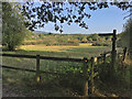
Footpath crossing on Dairy House nature reserve
Junction of footpaths Capel 190 and 191 on Dairy House private nature reserve, with view north over Capel village.
Image: © Hugh Craddock
Taken: 19 Sep 2020
0.11 miles