IMAGES TAKEN NEAR TO
The Street, DORKING, RH5 5JX
Introduction
This page details the photographs taken nearby to The Street, RH5 5JX by members of the Geograph project.
The Geograph project started in 2005 with the aim of publishing, organising and preserving representative images for every square kilometre of Great Britain, Ireland and the Isle of Man.

There are currently over 7.5m images from over14,400 individuals and you can help contribute to the project by visiting https://www.geograph.org.uk
Image Map
Images are licensed for reuse under creativecommons.org/licenses/by-sa/2.0
Notes
- Clicking on the map will re-center to the selected point.
- The higher the marker number, the further away the image location is from the centre of the postcode.
Image Listing (93 Images Found)
Images are licensed for reuse under creativecommons.org/licenses/by-sa/2.0
Image
Details
Distance
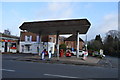
4
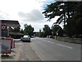
The Street Capel
This road that connects Clark's Green with Beare Green was formerly the A24.
Image: © Dave Spicer
Taken: 11 Aug 2013
0.03 miles
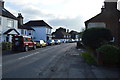
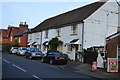
5
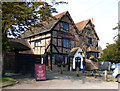
Capel: The 'Crown'
Looks promising, although I was a little too early to investigate
Image: © Dr Neil Clifton
Taken: 11 Mar 2015
0.03 miles
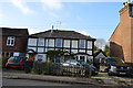
7
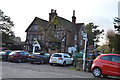
The Crown
Grade II listed. http://www.britishlistedbuildings.co.uk/en-290221-the-crown-inn-capel-surrey
Image: © N Chadwick
Taken: 30 Nov 2014
0.03 miles