IMAGES TAKEN NEAR TO
Horsham Road, DORKING, RH5 5JN
Introduction
This page details the photographs taken nearby to Horsham Road, RH5 5JN by members of the Geograph project.
The Geograph project started in 2005 with the aim of publishing, organising and preserving representative images for every square kilometre of Great Britain, Ireland and the Isle of Man.

There are currently over 7.5m images from over14,400 individuals and you can help contribute to the project by visiting https://www.geograph.org.uk
Image Map
Images are licensed for reuse under creativecommons.org/licenses/by-sa/2.0
Notes
- Clicking on the map will re-center to the selected point.
- The higher the marker number, the further away the image location is from the centre of the postcode.
Image Listing (3 Images Found)
Images are licensed for reuse under creativecommons.org/licenses/by-sa/2.0
Image
Details
Distance
1
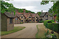
Osbrooks
This rather splendid timber framed house has all the brick infill in a herring-bone pattern.
Image: © Robin Webster
Taken: 26 Jul 2010
0.02 miles
3
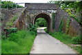
Railway bridge BTH3 / 343
This carries the Horsham-Dorking line over the drive to Osbrooks.
Image: © Robin Webster
Taken: 26 Jul 2010
0.25 miles