IMAGES TAKEN NEAR TO
Horsham Road, DORKING, RH5 5JL
Introduction
This page details the photographs taken nearby to Horsham Road, RH5 5JL by members of the Geograph project.
The Geograph project started in 2005 with the aim of publishing, organising and preserving representative images for every square kilometre of Great Britain, Ireland and the Isle of Man.

There are currently over 7.5m images from over14,400 individuals and you can help contribute to the project by visiting https://www.geograph.org.uk
Image Map
Images are licensed for reuse under creativecommons.org/licenses/by-sa/2.0
Notes
- Clicking on the map will re-center to the selected point.
- The higher the marker number, the further away the image location is from the centre of the postcode.
Image Listing (8 Images Found)
Images are licensed for reuse under creativecommons.org/licenses/by-sa/2.0
Image
Details
Distance
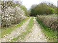
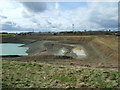
1
Looking across quarry from bridleway
See also http://www.geograph.org.uk/photo/1779315.
Image: © Shazz
Taken: 30 Mar 2017
0.08 miles
2
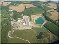
Mole Valley : Clay Pit
From a British Airways plane looking down towards a clay pit in Surrey.
Image: © Lewis Clarke
Taken: 1 Sep 2011
0.10 miles
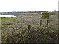
3
Clay Pit, Clock House, near Capel
Image: © Lorraine and Keith Bowdler
Taken: 28 Mar 2010
0.10 miles
4
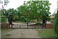
Ornamental gates, the Clock House
The rest of the premises seemed rather ornamented as well.
Image: © Robin Webster
Taken: 26 Jul 2010
0.14 miles
5
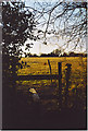
Wealden Fieldscape, west of Gages Farms.
Stile leading to grazing land with electric fences around it. A mast is in the middle distance.
Image: © Colin Smith
Taken: Unknown
0.18 miles
6
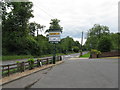
Mole Valley Morgan forecourt
By the A24.
Image: © Dave Spicer
Taken: 15 Jul 2012
0.18 miles
7
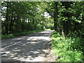
North on the Rusper Road
The lane joins the A24 near Capel.
Image: © Dave Spicer
Taken: 15 Jul 2012
0.22 miles