IMAGES TAKEN NEAR TO
Temple Lane, DORKING, RH5 5HJ
Introduction
This page details the photographs taken nearby to Temple Lane, RH5 5HJ by members of the Geograph project.
The Geograph project started in 2005 with the aim of publishing, organising and preserving representative images for every square kilometre of Great Britain, Ireland and the Isle of Man.

There are currently over 7.5m images from over14,400 individuals and you can help contribute to the project by visiting https://www.geograph.org.uk
Image Map
Images are licensed for reuse under creativecommons.org/licenses/by-sa/2.0
Notes
- Clicking on the map will re-center to the selected point.
- The higher the marker number, the further away the image location is from the centre of the postcode.
Image Listing (13 Images Found)
Images are licensed for reuse under creativecommons.org/licenses/by-sa/2.0
Image
Details
Distance
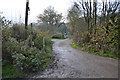
2
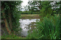
Pond near Rushetts
Just off the footpath, there is a summerhouse and staging on the left for secluded fishing or contemplation of the ducks.
Image: © Robin Webster
Taken: 26 Jul 2010
0.06 miles
10
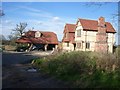
House under construction at Aldhurst Farm
looking north-east from Temple Lane
Image: © Andrew Longton
Taken: 6 Apr 2006
0.21 miles