IMAGES TAKEN NEAR TO
Partridge Lane, DORKING, RH5 5EE
Introduction
This page details the photographs taken nearby to Partridge Lane, RH5 5EE by members of the Geograph project.
The Geograph project started in 2005 with the aim of publishing, organising and preserving representative images for every square kilometre of Great Britain, Ireland and the Isle of Man.

There are currently over 7.5m images from over14,400 individuals and you can help contribute to the project by visiting https://www.geograph.org.uk
Image Map
Images are licensed for reuse under creativecommons.org/licenses/by-sa/2.0
Notes
- Clicking on the map will re-center to the selected point.
- The higher the marker number, the further away the image location is from the centre of the postcode.
Image Listing (5 Images Found)
Images are licensed for reuse under creativecommons.org/licenses/by-sa/2.0
Image
Details
Distance
4
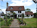
Footpath route by Upwey
The footpath passes remarkably close to the back door of small house near the main house. It may be a diversion from a route to the right of this house and so closer to the main house, as shown erroneously on the OS 1:50000 map.
Image: © Robin Webster
Taken: 30 Jun 2010
0.23 miles
5
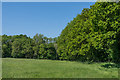
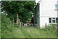
Field edge
Field edge east of Partridge Lane.
Image: © Ian Capper
Taken: 20 May 2018
0.24 miles